more stats
4,173 ft
Distance
-672 ft
Descent
00:10:18
Avg time
-672 ft
Altitude change
1,317 ft
Altitude min
1,989 ft
Altitude max
1,989 ft
Altitude start
1,316 ft
Altitude end
-16.1%
Grade
-41.9%
Grade max
-3.7%
Grade min
4,173 ft
Distance down
00:10:18
Avg time

Expresso Details

  • Activities
    • Mountain Bike
    • E-Bike
    • Trail Running
  • Riding Area
    Mount Fromme
    North Vancouver, British Columbia
  • AKA
    Espresso
  • Difficulty Rating
  • Voted Difficulty
    Blue (68 votes)
  • Local Popularity
    100 in Mountain Biking [+]
    • 100 in E-Biking
    • 75 in Trail Running
  • Global Ranking
    #4 in Mountain Biking [+]
    • #17 in E-Biking
    • #16 in Trail Running
  • Trail Type
    Singletrack
  • Bike Type
    AM, XC
  • Direction
    Downhill Primary
    Popular Direction Shown
  • Dogs Allowed
    Yes
  • eBike Allowed
    Yes up to Class 1
  • Land Owner
    Grouse (top 150m) + District of North Vancouver

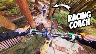
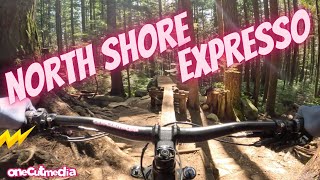
Thanks to a huge community effort over the span of 4 years led by Digger & the NSMBA, MEC & nsmb.com Expresso now represents a new era of North Shore flow. A golden ribbon of dirt filled with bermed corners from top to bottom, both intermediate and expert riders alike will enjoy the trail with optional tables, roll downs and of course, the big smooth rock ride. Some mandatory woodwork will put this into the category of a black diamond trail for most riders but hey, this is the Shore and is a blue as far as locals are concerned.

Trail Supporters
  • MEC
    MEC

    since 2012
    Sponsor

  • Digger

    since 2012
    Builder
  • Trevor Hansen
    Builder
Local Trail Association

Recent Activity on Trail

Past Week
  • 80 rides
  • 10 miles average
6 Months
  • 1,251 rides
  • 9 miles avg distance
All
  • 12,863 rides
  • Last: Jun 19, 2026
c1c2c3c4
January
February
March
April
May
June
July
August
September
October
November
December
update trails status or condition

Expresso Trail Reports

statusdatedescription
Jun 15, 2026 @ 3:44pm (Pacific/Auckland)
Jun 14, 2026
Airpods found and left on bench at start of trail
Jun 8, 2026 @ 5:18pm (Pacific/Auckland)
Jun 7, 2026
Deeply rutted in multiple muddy spots on the top half of the trail.
Jun 8, 2026 @ 2:22pm (Pacific/Auckland)
Jun 7, 2026
Running nice and all the work is great. Lots of puddles and sloppy parts also.
Jun 6, 2026 @ 7:04am (Pacific/Auckland)
Jun 5, 2026
Key/knife found at espresso trail head. I have left it at the water refill station near the entrance of Fromme access road where the baden Powell...
May 28, 2026 @ 1:02pm (America/Vancouver)
May 28, 2026
Fairy dusted
more »
Status:
on Jun 15, 2026
Dry
Avg: 4.52 (286 votes)
Your vote: 0

view (73,875)
close
3D
Trail Conditions
  • Unknown
  • Snow Groomed
  • Snow Packed
  • Snow Covered
  • Snow Cover Partial
  • Freeze/thaw Cycle
  • Icy
  • Prevalent Mud
  • Wet
  • Variable
  • Ideal
  • Dry
  • Very Dry
Trail Flow (Ridden Direction)
Trailforks scans users ridelogs to determine the most popular direction each trail is ridden. A good flowing trail network will have most trails flowing in a single direction according to their intension.
The colour categories are based on what percentage of riders are riding a trail in its intended direction.
  • > 96%
  • > 90%
  • > 80%
  • > 70%
  • > 50%
  • < 50%
  • bi-directional trail
  • no data
Trail Last Ridden
Trailforks scans ridelogs to determine the last time a trail was ridden.
  • < 2 days
  • < 1 week
  • < 2 weeks
  • < 1 month
  • < 6 months
  • > 6 months
Trail Ridden Direction
The intended direction a trail should be ridden.
  • Downhill Only
  • Downhill Primary
  • Both Directions
  • Uphill Primary
  • Uphill Only
  • One Direction
Contribute Details
Colors indicate trail is missing specified detail.
  • Description
  • Photos
  • Description & Photos
  • Videos
Trail Popularity ?
Trailforks scans ridelogs to determine which trails are ridden the most in the last 9 months. Trails are compared with nearby trails in the same city region with a possible 25 colour shades. Think of this as a heatmap, more rides = more kinetic energy = warmer colors.
  • most popular
  • popular
  • less popular
  • not popular
ATV/ORV/OHV Filter
Max Vehicle Width
inches
US Cell Coverage
Legend
cell carrier legend

Radar Time
Activity Recordings
Trailforks uses anonymized public activity data. ?
Activity Recordings
Trailforks uses anonymized public activity data. ?
Personal Heatmap
Activity Types
all / none
Options
2
Date range month
Winter Trails
Warning A routing network for winter maps does not exist. Selecting trails using the winter trails layer has been disabled.
Missing Trails
Most Popular
Least Popular
Trails are colored based on popularity. The more popular a trail is, the more red. Less popular trails trend towards green.
Jump Magnitude Heatmap
Heatmap of where riders jump on trails. Zoom in to see individual jumps, click circles to view jump details.
BC Backroad Status

Service Road Atlas is a free to use, community-driven service for viewing and creating reports on the numerous back-country service roads around B.C. and Alberta.

map legend
Slope Aspect
Direction the slope faces
Flat N NE E SE S SW W NW
Trails Deemphasized
Trails are shown in grey.
disable
Only show trails with no bike usage.
Enable
Suggested Layers
Based on selected activity type

    Save the current map location and zoom level as your default home location whenever this page is loaded.

    Save
        Directions to expresso trailhead (49.358830, -123.052240)

        Photos

        590 more »
        3,543 |
        Jul 17, 2014 @ 5:39pm
        Jul 17, 2014
        4,166 |
        Oct 15, 2015 @ 7:58pm
        Oct 15, 2015
        2,671 |
        Jun 30, 2014 @ 1:46am
        Jun 30, 2014
        40 |
        May 20, 2026 @ 1:47pm
        May 20, 2026

        Videos

        130 more »
        youtuber This is Why you Pre-Ride the Race Course...
        15:51 | 393 | May 18, 2025 , North Vancouver
        youtuber He's Memorized the North Shore; Can I Keep Up?
        11:29 | 456 | Jan 25, 2025 , North Vancouver
        youtuber A North Shore Classic   Expresso   Mt Fromme...
        10:59 | 2237 | May 10, 2023 , North Vancouver
        youtuber Expresso  ||  Mt Fromme, North Vancouver [Ep#62]
        11:11 | 5160 | Nov 19, 2018 , North Vancouver

        Articles

        Video: Geoff Gulevich's Express eMTB Lap On the North Shore's Expresso
        Sep 11, 2020 from pinkbike.com
        A quick one on a classic trail.

        Trail Lists

        Routes with this trail

        3.0 8 miles 1,917 ft 9 Loop
        A classic challenging shore ride featuring and . Read more about routes and riding in the North Shore by...
        4.0 6 miles 1,567 ft 8 Loop
        As much flow as you will find on Fromme with a bit of tech thrown in.
        5.0 7 miles 1,545 ft 6
        Testing the new routes system.

        Trail Events

        23 Reviews & Comments


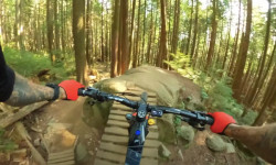
        We hope you've been enjoying Trailforks!

        Create a FREE account to view trail comments and much more.

        Frequently Asked Questions About Expresso

        Where is Expresso located?
        Expresso is located in Mount Fromme, North Vancouver, British Columbia, Canada. It is part of the Mount Fromme trail network. The trailhead is located at coordinates 49.35883, -123.05224.
        How hard is Expresso?
        Expresso is rated as Black Diamond difficulty. The average grade is 16.1%.
        What is the elevation gain for Expresso?
        The trail has 672 ft of elevation descent. The elevation ranges from 1,317 ft to 1,989 ft.
        Is Expresso a point to point trail?
        Expresso is not a point to point trail. The direction is Downhill Primary. The trail type is singletrack.

        Hit the Trail

        Open in App

        Get this trail on your phone instantly.
        open trail in app

        Download Trail

        Save to wishlist, Garmin & download.
        save the trail

        Find Related Routes

        Find routes and users activities that include this trail.
        find routes for this trail

        You must enter a description before submitting.