Supporters, Builders, Maintainers & Land Managers of Howler (lower) Trail
- Zander StrathearnBuilder
Howler (lower) Details
-
Activities
- Mountain Bike
- E-Bike
- Hike
- Trail Running
-
Riding AreaWestside - Rainbow
Whistler, British Columbia -
Difficulty Rating
-
Trail TypeSingletrack
-
Bike TypeAM
-
DirectionDownhill PrimaryPopular direction shown
-
Physical RatingModerate
-
SeasonJun-Oct
-
Dogs AllowedYes
-
eBike AllowedYes up to Class 1
-
TTFs on TrailRock Face
-
Ride in RainYes
-
Global Ranking
-
Local Popularity75 in Mountain Biking [+]
- 75 in E-Biking
- 50 in Trail Running
- 60 in Hiking
-
Year Opened2013
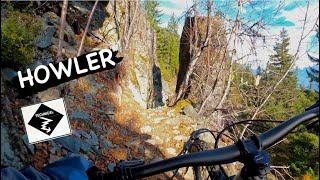
This trail is a great wet weather trail, Lower Howler is in low angle terrain compared to the upper two sections but still, have great views. The is just enough tech to keep you on your toes, but with enough flow you can open it up and really enjoy it, knowing there are no major features, drops, or jumps, to catch you unawares. The rock up there, however, is sharp so bring spare tubes
Access Info
Starting from the very top of Alpine Way (no parking), climb Cultured Climb to Rick's Roost (name of the access road, not an actual trail) until you don't want to climb any more. You will pass Cat Scratch Fever, Green Monster, and the Flank turn-off to Billy Epic. Keep going. Past the Flank, the trail mellows until you reach a big bridge over 19 mile creek. Shortly after the creek, you will pass the Skywalk Hiking trail on your left and you will see a motor-vehicle gate straight ahead, take the right towards Lower Skywalk and Lower Howler. The access is an old low angle slightly wet skidder road that contours, expect to see hikers as its the primary access to the hiking trail network, continue along the roadbed until you reach Howler.
Local Trail Association
-
Please consider joining or donating to the local trail association to supportdonate to earn trail karma!
trail development & maintenance.
Traditionally Indigenous Territory
More Stats for Howler (lower) mountain bike trail trail
-
Altitude change-1,066 ft
-
Altitude min2,455 ft
-
Altitude max3,521 ft
-
Altitude start3,521 ft
-
Altitude end2,454 ft
-
Grade-20.2%
-
Grade max-44.9%
-
Grade min2.5%
-
Distance climb92 ft
-
Distance down5,151 ft
-
Distance flat36 ft
-
Avg time00:12:48
- view trail stats
- Unknown
- Snow Groomed
- Snow Packed
- Snow Covered
- Snow Cover Inadequate
- Freeze/thaw Cycle
- Icy
- Prevalent Mud
- Wet
- Variable
- Ideal
- Dry
- Very Dry
The colour categories are based on what percentage of riders are riding a trail in its intended direction.
- > 96%
- > 90%
- > 80%
- > 70%
- > 50%
- < 50%
- bi-directional trail
- no data
- < 2 days
- < 1 week
- < 2 weeks
- < 1 month
- < 6 months
- > 6 months
- Downhill Only
- Downhill Primary
- Both Directions
- Uphill Primary
- Uphill Only
- One Direction
- Description
- Photos
- Description & Photos
- Videos
- most popular
- popular
- less popular
- not popular
- mountain biking recent
- mountain biking (>6 month)
- hiking (1 year)
- moto (1 year)
- Downhill Ski
- Backcountry Ski
- Nordic Ski
- Snowmobile
Save the current map location and zoom level as your default home location whenever this page is loaded.
SaveHowler (lower) Trail Reports
Recent Ridelog Activity on Trail
Past Week
- 0 rides
6 Months
- 158 rides
- 12 miles avg distance
All
- 3,136 rides
- Last: Jun 28, 2022
Photos
Routes with this trail
Trail Products
-
WORCA Trail PassTrail Pass
9 Reviews & Comments
-
- 2


This is up near the top of my favourite Whistler descents.
Videos
Nearby Trails
- Howler (mid) 2,080 ft
- Rainbow-sproatt Flank 2,080 ft
- Howler (upper) 3,888 ft
- Rainbow-sproatt Flank (north/19 Mile) 4,177 ft
- Prowler 5,056 ft
- embed Howler (lower) trail on your website
- By Hwulex
& contributors
- #6664 - 19,053 views
- subscribe
- login to download gpx or kml files.