close
-
Layers w
- Map Content
- More Layers
- Pro
- Pro
- Pro
- Pro
- Pro
- Pro
- Pro
- Pro
-
Upgrade to

3D
Trail Conditions
- Unknown
- Snow Groomed
- Snow Packed
- Snow Covered
- Snow Cover Partial
- Freeze/thaw Cycle
- Icy
- Prevalent Mud
- Wet
- Variable
- Ideal
- Dry
- Very Dry
Trail Flow (Ridden Direction)
Trailforks scans users ridelogs to determine the most popular direction each trail is ridden. A good flowing trail network will have most trails flowing in a single direction according to their intension.
The colour categories are based on what percentage of riders are riding a trail in its intended direction.
The colour categories are based on what percentage of riders are riding a trail in its intended direction.
- > 96%
- > 90%
- > 80%
- > 70%
- > 50%
- < 50%
- bi-directional trail
- no data
Trail Last Ridden
Trailforks scans ridelogs to determine the last time a trail was ridden.
- < 2 days
- < 1 week
- < 2 weeks
- < 1 month
- < 6 months
- > 6 months
Trail Ridden Direction
The intended direction a trail should be ridden.
- Downhill Only
- Downhill Primary
- Both Directions
- Uphill Primary
- Uphill Only
- One Direction
Contribute Details
Colors indicate trail is missing specified detail.
- Description
- Photos
- Description & Photos
- Videos
Trail Popularity ?
Trailforks scans ridelogs to determine which trails are ridden the most in the last 9 months.
Trails are compared with nearby trails in the same city region with a possible 25 colour shades.
Think of this as a heatmap, more rides = more kinetic energy = warmer colors.
- most popular
- popular
- less popular
- not popular
ATV/ORV/OHV Filter
Max Vehicle Width
inches
US Cell Coverage
Legend

Radar Time
x
Activity Recordings
Trailforks users anonymized public ridelogs from the past 6 months.
- mountain biking recent
- mountain biking (>6 month)
- hiking (1 year)
- moto (1 year)
Activity Recordings
Trailforks users anonymized public skilogs from the past 12 months.
- Downhill Ski
- Backcountry Ski
- Nordic Ski
- Snowmobile
Winter Trails
Warning
A routing network for winter maps does not exist. Selecting trails using the winter trails layer has been disabled.
x
Missing Trails
Most Popular
Least Popular
Trails are colored based on popularity. The more popular a trail is, the more red. Less popular trails trend towards green.
Jump Magnitude Heatmap
Heatmap of where riders jump on trails. Zoom in to see individual jumps, click circles to view jump details.
Trails Deemphasized
Trails are shown in grey.
Only show trails with NO bikes.
Save the current map location and zoom level as your default home location whenever this page is loaded.
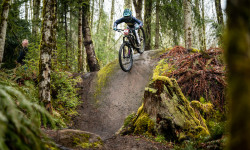
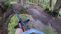
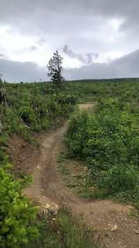
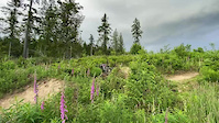
SaveGalbraith Mountain is a world class mountain destination located within riding distance of downtown Bellingham. Over 70 miles of singletrack that winds through over 3000 acres overlooking the city and Bellingham Bay.
All of the trails are built and maintained by the WMBC.
All of the trails are built and maintained by the WMBC.
Primary Trail Type: All-Mountain & Downhill
eBikes Allowed:
Yes
AKA: Galby
Land Status: Managed by Local Riding Association
 google parking directions
 Activities Click to view
- Mountain Bike
180 trails
- E-Bike
3 trails
- Horse
0 trails
- Hike
148 trails
- Trail Running
149 trails
Region Details
- 50
- 104
- 16
- 3
- 2
Region Status
Open as of 2 daysLocal Trail Association
Stats
- Avg Trail Rating
- Trails (view details)
- 177
- Trails Mountain Bike
- 181
- Trails E-Bike
- 3
- Trails Hike
- 148
- Trails Trail Running
- 149
- Total Distance
- 70 miles
- Total Descent
- 17,515 ft
- Total Vertical
- 1,406 ft
- Highest Trailhead
- 1,784 ft
- Reports
- 13,702
- Photos
- 2,199
- Ridden Counter
- 355,872
 Articles
Race Report: Galbraith Gravity Spring Series Race #4 Air Chair
Apr 30, 2023 from pinkbike.com
We had a double header this weekend.

Northwest Tune-Up, Bike, Music & Beer Festival, Returns to Bellingham, WA, July 14-16, 2023
Dec 7, 2022 from pinkbike.com
The Northwest Tune-Up, the Pacific Northwest’s premier bikes, music and beer festival, will return to beautiful Bellingham, WA, July 14-16.
Recap: The First-Ever NW Tune-Up Festival Featured Bikes & Music in Bellingham
Jul 13, 2022 from pinkbike.com
The celebration of PNW culture was a big hit.
Hannah Bergemann's Hangtime Freeride Event Returns for 2022
Sep 13, 2022 from pinkbike.com
Hangtime, a women’s freeride event hosted by Hannah Bergemann on the Blue Steel jump line in Bellingham, Washington, will be returning for 2022.
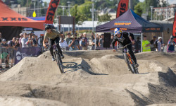
Popular Galbraith Mountain Biking Trails
Galbraith Mountain Bike Routes
| title | rating | distance |
|---|---|---|
| 2023 CDC Enduro Bonus Round Galbraith: Sport Course | 12 miles | |
| Demo Route | 14 miles | |
| 2023 CDC Enduro Bonus Round Galby Pro/Expert/Hardtail | ||
| Quick Noob Loop - South Side | 5 miles | |
| Vikes Galbraith Loop | 20 miles | |
| Grasshopper to sst from birch | 6 miles | |
| South Side Flow Trails | 7 miles | |
| galbraith xc loop to u-line | 9 miles | |
| Top Three Steep Rock Rolls | 9 miles | |
| SST Quick Lap | 5 miles |
Photos of Galbraith Mountain Bike
trail: Mohawk
1,605 |
Oct 29, 2018 @ 7:29pm
Oct 29, 2018
trail: Oly
343 |
Sep 29, 2018 @ 5:02pm
Sep 29, 2018
trail: Das Auto Bahn
1,148 | | 1 comments
Sep 8, 2018 @ 7:35pm
Sep 8, 2018
trail: El Pollo Elastico
395 |
Jul 12, 2017 @ 12:04am
Jul 12, 2017
trail: Lair of the Bear
828 |
Mar 31, 2017 @ 9:34am
Mar 31, 2017
trail: Irish Death
2,627 | | 3 comments
Mar 31, 2017 @ 9:33am
Mar 31, 2017
trail: Wonderland
796 | | 1 comments
Jun 26, 2016 @ 3:16pm
Jun 26, 2016Videos of Galbraith Mountain Bike

trail: SST Alt
|
May 18, 2024
trail: 911
42 |
Nov 17, 2023

trail: Mohawk
61 |
Jul 11, 2023

trail: Vitamin R
|
Jun 22, 2023
trail: Boot Dryer
491 |
Apr 10, 2023
trail: Cedar Dust Black Jump Line
341 |
Jul 17, 2022

trail: Boot Dryer
341 |
Jul 17, 2022
trail: Cedar Dust Pro Jump Line
325 |
Jun 24, 2022
Current Trail Warnings
| status | trail | date | condition | user | info |
|---|---|---|---|---|---|
| Stick | May 14, 2024 @ 2:48pm May 14, 2024 | Ideal | Tf-es | Janky bridge has a board coming loose | |
| Cedar Dust Pro Jump Line | May 4, 2024 @ 6:37am May 4, 2024 | Ideal | LucasCannizzaro | ||
| Tough Love | May 2, 2024 @ 3:09pm May 2, 2024 | Unknown | vermin02 |
Recent Trail Reports
| status | trail | date | condition | info | user |
|---|---|---|---|---|---|
| Family Fun Center | May 18, 2024 @ 5:38am 2 days | Ideal | tchsurg | ||
| El Pollo Connector | May 18, 2024 @ 5:38am 2 days | Ideal | tchsurg | ||
| El Pollo Elastico | May 18, 2024 @ 5:38am 2 days | Ideal | tchsurg | ||
| Wonderland | May 18, 2024 @ 5:38am 2 days | Ideal | tchsurg | ||
| Wonderland (lower) | May 18, 2024 @ 5:38am 2 days | Ideal | tchsurg | ||
| Papa locks | May 18, 2024 @ 5:38am 2 days | Ideal | tchsurg | ||
| Bearly There | May 18, 2024 @ 5:38am 2 days | Ideal | tchsurg | ||
| Baby Bear | May 18, 2024 @ 5:38am 2 days | Ideal | tchsurg | ||
| Papa Bear | May 18, 2024 @ 5:38am 2 days | Ideal | tchsurg | ||
| Tweedle Dee & Tweedle Dum | May 18, 2024 @ 5:38am 2 days | Ideal | tchsurg |
Activity Feed
| username | action | type | title | date |
|---|---|---|---|---|
| bsavery | wishlist | route | activity #52878197 | May 20, 2024 @ 6:11am 1 hours |
| Smcconnell02 | wishlist | route | activity #52859121 | May 19, 2024 @ 10:34pm 9 hours |
| tchsurg | add | report | activity #52858133 and 9 more | May 19, 2024 @ 10:06pm 9 hours |
| KristaNorthcott | wishlist | route | activity #52853599 | May 19, 2024 @ 8:05pm 11 hours |
| mman1506 | wishlist | route | activity #52849667 | May 19, 2024 @ 6:33pm 13 hours |
Recent Comments
| username | type | title | comment | date |
|---|---|---|---|---|
| report | Tree down not too far into the trail | May 16, 2024 @ 4:01pm May 16, 2024 | ||
| trail | These jumps are sick so floaty and smooth | May 14, 2024 @ 8:59pm May 14, 2024 | ||
| trail | Is this supposed to be an equestrian trail? | May 14, 2024 @ 2:55pm May 14, 2024 | ||
| trail | RIP | May 13, 2024 @ 5:33pm May 13, 2024 | ||
| trail | Trail is open now opens in April. | May 13, 2024 @ 6:19am May 13, 2024 |
Nearby Areas
| name | distance | ||||
|---|---|---|---|---|---|
| Lake Padden | 1 | 5 | 2 km | ||
| Samish Crest Open Space | 28 | 7 | 2.1 km | ||
| Whatcom Falls Park | 9 | 1 | 2.8 km | ||
| Hog's Pond | 4 | 3.4 km | |||
| Lookout Mountain | 2 | 4 | 15 | 3 | 3.7 km |
Local Badges
-

Completionist2 awarded
Bike & Skill Parks
| name | type | city | rating |
|---|---|---|---|
| Whatcom Falls Pump Track | skill park | Bellingham | |
| Cedar Dust Jump Lines | skill park | Bellingham | |
| Galbraith Dirt Jumps | skill park | Bellingham |
Activity Type Stats
| activitytype | trails | distance | descent | descent distance | total vertical | rating | global rank | state rank | photos | reports | routes | ridelogs |
|---|---|---|---|---|---|---|---|---|---|---|---|---|
| Mountain Bike | 180 | 68 miles | 17,136 ft | 35 miles | 1,407 ft | #2 | #1 | 2,163 | 13,658 | 91 | 138,834 | |
| E-Bike | 3 | #1 | #1 | 2 | 11,210 | 3,895 | ||||||
| Hike | 148 | 57 miles | 10,801 ft | 24 miles | 1,407 ft | #2 | #1 | 5 | 12,722 | 1,425 | ||
| Trail Running | 149 | 59 miles | 11,388 ft | 25 miles | 1,407 ft | #2 | #1 | 29 | 12,740 | 16 | 3,414 |
- By kyleyoungtransition & contributors
- Admins: WMBC, WMBC
- #3279 - 321,322 views
- galbraith activity log | embed map of Galbraith mountain bike trails | galbraith mountain biking points of interest
Downloading of trail gps tracks in kml & gpx formats is enabled for Galbraith.
You must login to download files.