more stats
2.1 miles
Distance
280 ft
Climb
-275 ft
Descent
00:22:02
Avg time
3 ft
Altitude change
3,957 ft
Altitude min
4,133 ft
Altitude max
4,016 ft
Altitude start
4,019 ft
Altitude end
-27.7%
Grade max
19.5%
Grade min
4,715 ft
Distance climb
3,593 ft
Distance down
2,982 ft
Distance flat
00:22:02
Avg time

Baldwin Details

  • Activities
    • Mountain Bike
    • Horse
    • Hike
    • Trail Running
  • Riding Area
    Cathedral
    Village Of Oak Creek, Arizona
  • Ref Number
    #191
  • Difficulty Rating
  • Voted Difficulty
    Black Diamond (2 votes)
  • Local Popularity
    35 in Mountain Biking [+]
    • 40 in Trail Running
    • 70 in Hiking
    • 5 in Horseback
  • Global Ranking
    #4032 in Mountain Biking [+]
    • #82742 in Trail Running
    • #50982 in Hiking
  • Trail Type
    Singletrack
  • Direction
    Both Directions
    Popular In Reverse
  • Dogs Allowed
    Yes
  • eBike Allowed

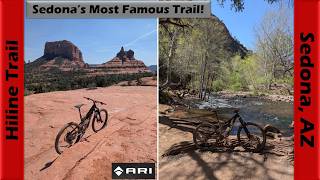
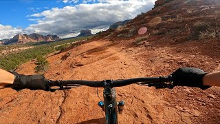
Intermediate 60% and advanced 60%, MTB trail which is a bi-directional singletrack, that is twisty, up and down with many short technical sections a lesser skilled rider may walk. The trail tread is mostly packed dirt mixed with rocks and there are some slickrock sections. I would say the preferred direction is counter clockwise. Also the south section of the trail is a great connector for a fun technical loop.

Trail Supporters

  • USFS
    Land Manager
Local Trail Association

Recent Activity on Trail

Past Week
  • 0 rides
  •  
6 Months
  • 31 rides
  • 14 miles avg distance
All
  • 243 rides
  • Last: Jun 22, 2026
c1c2c3c4
January
February
March
April
May
June
July
August
September
October
November
December
update trails status or condition

Baldwin Trail Reports

Status:
on Jul 1, 2024
Ideal
Avg: 4.21 (30 votes)
Your vote: 0

view (1,655)
close
3D
Trail Conditions
  • Unknown
  • Snow Groomed
  • Snow Packed
  • Snow Covered
  • Snow Cover Partial
  • Freeze/thaw Cycle
  • Icy
  • Prevalent Mud
  • Wet
  • Variable
  • Ideal
  • Dry
  • Very Dry
Trail Flow (Ridden Direction)
Trailforks scans users ridelogs to determine the most popular direction each trail is ridden. A good flowing trail network will have most trails flowing in a single direction according to their intension.
The colour categories are based on what percentage of riders are riding a trail in its intended direction.
  • > 96%
  • > 90%
  • > 80%
  • > 70%
  • > 50%
  • < 50%
  • bi-directional trail
  • no data
Trail Last Ridden
Trailforks scans ridelogs to determine the last time a trail was ridden.
  • < 2 days
  • < 1 week
  • < 2 weeks
  • < 1 month
  • < 6 months
  • > 6 months
Trail Ridden Direction
The intended direction a trail should be ridden.
  • Downhill Only
  • Downhill Primary
  • Both Directions
  • Uphill Primary
  • Uphill Only
  • One Direction
Contribute Details
Colors indicate trail is missing specified detail.
  • Description
  • Photos
  • Description & Photos
  • Videos
Trail Popularity ?
Trailforks scans ridelogs to determine which trails are ridden the most in the last 9 months. Trails are compared with nearby trails in the same city region with a possible 25 colour shades. Think of this as a heatmap, more rides = more kinetic energy = warmer colors.
  • most popular
  • popular
  • less popular
  • not popular
ATV/ORV/OHV Filter
Max Vehicle Width
inches
US Cell Coverage
Legend
cell carrier legend

Radar Time
Activity Recordings
Trailforks uses anonymized public activity data. ?
Activity Recordings
Trailforks uses anonymized public activity data. ?
Personal Heatmap
Activity Types
all / none
Options
2
Date range month
Winter Trails
Warning A routing network for winter maps does not exist. Selecting trails using the winter trails layer has been disabled.
Missing Trails
Most Popular
Least Popular
Trails are colored based on popularity. The more popular a trail is, the more red. Less popular trails trend towards green.
Jump Magnitude Heatmap
Heatmap of where riders jump on trails. Zoom in to see individual jumps, click circles to view jump details.
BC Backroad Status

Service Road Atlas is a free to use, community-driven service for viewing and creating reports on the numerous back-country service roads around B.C. and Alberta.

map legend
Slope Aspect
Direction the slope faces
Flat N NE E SE S SW W NW
Trails Deemphasized
Trails are shown in grey.
disable
Only show trails with no bike usage.
Enable
Suggested Layers
Based on selected activity type

    Save the current map location and zoom level as your default home location whenever this page is loaded.

    Save
        Directions to baldwin trailhead (34.822120, -111.807460)

        Photos

        20 more »
        269 |
        Jun 29, 2017 @ 6:36am
        Jun 29, 2017
        113 |
        Nov 25, 2021 @ 11:15am
        Nov 25, 2021
        91 |
        Nov 25, 2021 @ 11:15am
        Nov 25, 2021
        137 |
        Sep 29, 2020 @ 11:37am
        Sep 29, 2020

        Videos

        8 more »
        youtuber Does Hiline Trail live up to the hype!? |...
        33:16 | 75 | Apr 24, 2026 , Village Of Oak Creek
        Baldwin - Sedona, AZ - MTB Trail Preview
        0:11 | 138 | Mar 19, 2025 , Village Of Oak Creek
        When you finish HILINE, still plenty of fun!...
        4:08 | 202 | Jan 13, 2023 , Village Of Oak Creek
        MTB Riding HiLine and More at Sedona, May 2, 2021
        44:04 | 218 | Nov 1, 2021 , Village Of Oak Creek

        Trail Lists

        Routes with this trail

        4.0 10 miles 897 ft 7 Loop
        Sedona Classics! Featuring some long standing favorites like Slim Shady, , Llama, and trails. There are a...
        4.0 10 miles 1,317 ft 12 Loop
        is a "must do" bucket list ride for the experienced rider. Even if you have to walk the Double Black...
        5.0 9 miles 1,121 ft 11 Loop
        This is a good size loop if wanting to ride the iconic Trail in Sedona.

        7 Reviews & Comments


        We hope you've been enjoying Trailforks!

        Create a FREE account to view trail comments and much more.

        • By toddTF Pro Trailforks & contributors
        • #14538 - 6,749 views

        Frequently Asked Questions About Baldwin

        Where is Baldwin located?
        Baldwin is located in Cathedral, Village Of Oak Creek, Arizona, United States. It is part of the Cathedral trail network. The trailhead is located at coordinates 34.82212, -111.80746.
        How hard is Baldwin?
        Baldwin is rated as Blue difficulty.
        What is the elevation gain for Baldwin?
        Baldwin has 280 ft of elevation gain. The trail has 275 ft of elevation descent. The elevation ranges from 3,957 ft to 4,133 ft.
        Is Baldwin a point to point trail?
        Baldwin is not a point to point trail. The direction is Both Directions. The trail type is singletrack.

        Hit the Trail

        Open in App

        Get this trail on your phone instantly.
        open trail in app

        Download Trail

        Save to wishlist, Garmin & download.
        save the trail

        Find Related Routes

        Find routes and users activities that include this trail.
        find routes for this trail

        You must enter a description before submitting.