close
-
Layers w
- Map Content
- More Layers
- Pro
- Pro
- Pro
- Pro
- Pro
- Pro
- Pro
- Pro
-
Upgrade to

3D
Trail Conditions
- Unknown
- Snow Groomed
- Snow Packed
- Snow Covered
- Snow Cover Partial
- Freeze/thaw Cycle
- Icy
- Prevalent Mud
- Wet
- Variable
- Ideal
- Dry
- Very Dry
Trail Flow (Ridden Direction)
Trailforks scans users ridelogs to determine the most popular direction each trail is ridden. A good flowing trail network will have most trails flowing in a single direction according to their intension.
The colour categories are based on what percentage of riders are riding a trail in its intended direction.
The colour categories are based on what percentage of riders are riding a trail in its intended direction.
- > 96%
- > 90%
- > 80%
- > 70%
- > 50%
- < 50%
- bi-directional trail
- no data
Trail Last Ridden
Trailforks scans ridelogs to determine the last time a trail was ridden.
- < 2 days
- < 1 week
- < 2 weeks
- < 1 month
- < 6 months
- > 6 months
Trail Ridden Direction
The intended direction a trail should be ridden.
- Downhill Only
- Downhill Primary
- Both Directions
- Uphill Primary
- Uphill Only
- One Direction
Contribute Details
Colors indicate trail is missing specified detail.
- Description
- Photos
- Description & Photos
- Videos
Trail Popularity ?
Trailforks scans ridelogs to determine which trails are ridden the most in the last 9 months.
Trails are compared with nearby trails in the same city region with a possible 25 colour shades.
Think of this as a heatmap, more rides = more kinetic energy = warmer colors.
- most popular
- popular
- less popular
- not popular
ATV/ORV/OHV Filter
Max Vehicle Width
inches
US Cell Coverage
Legend

Radar Time
x
Activity Recordings
Trailforks users anonymized public ridelogs from the past 6 months.
- mountain biking recent
- mountain biking (>6 month)
- hiking (1 year)
- moto (1 year)
Activity Recordings
Trailforks users anonymized public skilogs from the past 12 months.
- Downhill Ski
- Backcountry Ski
- Nordic Ski
- Snowmobile
Winter Trails
Warning
A routing network for winter maps does not exist. Selecting trails using the winter trails layer has been disabled.
x
Missing Trails
Most Popular
Least Popular
Trails are colored based on popularity. The more popular a trail is, the more red. Less popular trails trend towards green.
Jump Magnitude Heatmap
Heatmap of where riders jump on trails. Zoom in to see individual jumps, click circles to view jump details.
Trails Deemphasized
Trails are shown in grey.
Only show trails with NO bikes.
Save the current map location and zoom level as your default home location whenever this page is loaded.
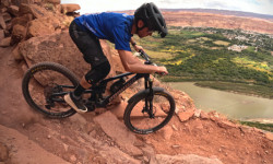
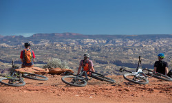
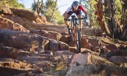
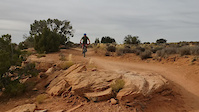
SaveHome of the original Slickrock and Upper Porcupine Singletrack Mountain Bike Trails, Moab has been the ultimate mountain bikers road trip destination for years. If coming from the north Klondike Bluffs is an excellent start, and will provide some very easy kid friendly trainer trails along with some medium level trails to get even seasoned experts warmed up. The Gemini Bridges area is usually my next target trail system hosting the Magnificent 7 (aka Mag 7) which will also connect to Gold Bar Rim. Head into town and over to Kane Creek to access the more expert level trails, with Captain Ahab and the Amasa Back area being the local favorites. Every year new mountain bike trails and trail systems are added, and the town offers a lively nightlife.
Activities Click to view
- Mountain Bike
434 trails
- E-Bike
145 trails
- Horse
44 trails
- Hike
565 trails
- Trail Running
552 trails
- Dirtbike/Moto
130 trails
- ATV/ORV/OHV
92 trails
- Snowshoe
5 trails
- Backcountry Ski
4 trails
- Nordic Ski
1 trails
Region Details
- 143
- 10
- 51
- 140
- 71
- 17
- 2
Region Status
Caution as of 1 dayLocal Trail Association
Stats
- Avg Trail Rating
- Trails (view details)
- 561
- Trails Mountain Bike
- 434
- Trails E-Bike
- 145
- Trails Horse
- 44
- Trails Hike
- 565
- Trails Trail Running
- 552
- Trails Dirtbike/Moto
- 130
- Trails Observed Trials
- 4
- Trails ATV/ORV/OHV
- 92
- Trails Snowshoe
- 5
- Trails Downhill Ski
- 3
- Trails Backcountry Ski
- 4
- Trails Nordic Ski
- 1
- Total Distance
- 1,182 mile
- Total Descent
- 170,722 ft
- Total Vertical
- 8,692 ft
- Highest Trailhead
- 12,607 ft
- Reports
- 9,445
- Photos
- 4,558
- Ridden Counter
- 418,042
 Articles

Details Announced for 2024 BetterRide MTB Skills Courses
Jan 17, 2024 from pinkbike.com
BetterRide has skills courses scheduled across the US.
Video: Remy Metailler Rides Infamous Portal Trail in Moab
Oct 20, 2023 from pinkbike.com
Remy checks out a trail that many people have on their bucket list. .
Holiday River & Bike Expeditions Offers Unique Access to Remote Section of Canyonlands National Park
Mar 18, 2023 from pinkbike.com
The company has expanded their offering of 5-day biking trips into the hard-to-access Maze District.
Hannah Otto Sets FKT on the Whole Enchilada
Nov 15, 2022 from pinkbike.com
Hannah's 6 hours and 47 minute time is the fastest know time for both men and women.
Sub Regions
-
Amasa Back
- 2
- 3
- 7
- 5
-
Arches National Park
-
Canyonlands National Park - Island in the Sky
- 1
-
Dead Horse Point
- 4
- 6
-
Horsethief
- 6
- 10
-
Klondike Bluffs
- 11
- 15
- 13
-
Klonzo
- 11
- 16
- 4
-
La Sal Mountains
- 1
- 22
- 17
- 2
- 1
-
Mag 7
- 2
- 10
- 3
- 2
- 1
-
Moab Brand Trails
- 9
- 11
- 4
- 1
-
Navajo Rocks
- 7
-
Sand Flats Recreation Area
- 1
- 1
- 14
- 4
- 1
-
Sovereign Trail System
- 1
- 6
- 9
- 3
Popular Moab Mountain Biking Trails
Moab Mountain Bike Routes
| title | rating | distance |
|---|---|---|
| Moab Double Down | 14 miles | |
| Brand to Klonzo Ultimate | 20 miles | |
| The Whole Enchilada - Moab, Utah | 27 miles | |
| Hymasa/Captain Ahab loop | 8 miles | |
| Always End on a Down Hill-Longer | 18 miles | |
| Navajo Rocks Loop! | 17 miles | |
| Navajo Rocks full loop | 17 miles | |
| 3/4 Enchilada - Starting on Hazard County at Miners Basin parking - RideSpots.com | 20 miles | |
| Falcon Flow Sand Flats Road Loop | 8 miles | |
| Mag 7 - Portal Finish | 21 miles |
Photos of Moab Mountain Bike
trail: TWE Beginning
1,394 |
Jan 21, 2018 @ 2:14pm
Jan 21, 2018
trail: Slickrock
1,964 |
Jan 19, 2018 @ 2:04pm
Jan 19, 2018
trail: Porcupine Rim Trail
4,952 |
Jan 19, 2018 @ 2:03pm
Jan 19, 2018
trail: Great Escape
971 |
Jan 19, 2018 @ 2:03pm
Jan 19, 2018
trail: Captain Ahab (lower)
1,944 |
Jan 19, 2018 @ 2:01pm
Jan 19, 2018
trail: Pothole Arch
223 |
Jan 7, 2018 @ 12:14pm
Jan 7, 2018
trail: Porcupine Rim Trail
2,139 |
Jan 7, 2018 @ 12:06pm
Jan 7, 2018
trail: Pothole Arch
441 | | 2 comments
Jun 5, 2013 @ 1:56pm
Jun 5, 2013Videos of Moab Mountain Bike

trail: Kokopelli - Whole Enchilada
|
Apr 11, 2024

trail: Kokopelli - Whole Enchilada
386 |
Jan 18, 2024

trail: Kokopelli - Whole Enchilada
16 |
Jan 15, 2024
trail: Slickrock
18 |
Nov 21, 2023
trail: Bull Run
36 |
Nov 21, 2023

trail: Hawks Glide
86 |
Apr 4, 2023

trail: Hawks Glide
28 |
Apr 4, 2023

trail: Hawks Glide
48 |
Mar 31, 2023
Recent Trail Reports
| status | trail | date | condition | info | user |
|---|---|---|---|---|---|
| Jasper West | Apr 7, 2024 @ 4:09am Apr 7, 2024 | Ideal | EdLCFudJ | ||
| Agate West | Apr 7, 2024 @ 4:09am Apr 7, 2024 | Ideal | EdLCFudJ | ||
| Alaska | Apr 6, 2024 @ 12:01pm Apr 6, 2024 | Ideal | extrapulp | ||
| Lower Jimmy Keen | Apr 5, 2024 @ 3:35pm Apr 5, 2024 | Snow Cover Partial | GrandCountyTrails MTM | ||
| Slickrock (practice) | Apr 2, 2024 @ 10:48am Apr 2, 2024 | Dry | UtahJohn TRAILFORKS | ||
| North 40 | Apr 2, 2024 @ 4:53am Apr 2, 2024 | Dry | UtahJohn TRAILFORKS | ||
| Maverick | Apr 2, 2024 @ 4:53am Apr 2, 2024 | Dry | UtahJohn TRAILFORKS | ||
| Lazy | Apr 2, 2024 @ 4:53am Apr 2, 2024 | Dry | UtahJohn TRAILFORKS | ||
| Wizard | Mar 28, 2024 @ 9:56pm Mar 28, 2024 | Ideal | MrFrumble | ||
| Carousel | Mar 28, 2024 @ 2:40pm Mar 28, 2024 | Ideal | MrFrumble |
Activity Feed
| username | action | type | title | date |
|---|---|---|---|---|
| twowheeledwanderer | update | route | activity #52836549 | May 19, 2024 @ 1:10pm 45 mins |
| agraffaz | wishlist | region | activity #52835005 | May 19, 2024 @ 12:15pm 2 hours |
| agraffaz | wishlist | region | activity #52834991 | May 19, 2024 @ 12:14pm 2 hours |
| agraffaz | wishlist | trail | activity #52834970 | May 19, 2024 @ 12:14pm 2 hours |
| agraffaz | wishlist | trail | activity #52834921 | May 19, 2024 @ 12:12pm 2 hours |
Recent Comments
| username | type | title | comment | date |
|---|---|---|---|---|
| trail | Fast and flowy indeed! So fun, we looped it! | May 18, 2024 @ 7:20pm 19 hours | ||
| trail | There are a few camp sites out here. Fwiw The... | May 17, 2024 @ 9:01am 2 days | ||
| trail | Fantastic trail. The Raptor Trails are way... | May 15, 2024 @ 12:27pm May 15, 2024 | ||
| report | Excellent Moab Starter riding at Dead Horse | May 14, 2024 @ 9:25am May 14, 2024 | ||
| report | May 14, 2024 @ 9:24am May 14, 2024 |
Local Badges
-

Big Ride 30k21,291 awarded -

Epic Ride 50k5,557 awarded -

Top 10 Trails1,232 awarded -

10 Black Trails2,939 awarded -

10 Blue Trails4,152 awarded -

10 Green Trails1,144 awarded
Bike & Skill Parks
| name | type | city | rating |
|---|---|---|---|
| Moab BMX Park | skill park | Moab |
Upcoming Local Events
-
-
Activity Type Stats
| activitytype | trails | distance | descent | descent distance | total vertical | rating | global rank | state rank | photos | reports | routes | ridelogs |
|---|---|---|---|---|---|---|---|---|---|---|---|---|
| Mountain Bike | 434 | 1,020 mile | 136,319 ft | 464 miles | 7,251 ft | #7 | #3 | 4,269 | 9,393 | 121 | 129,757 | |
| E-Bike | 145 | 505 miles | 50,896 ft | 214 miles | 6,755 ft | #55 | #16 | 14 | 7,943 | 8 | 2,299 | |
| Horse | 44 | 161 miles | 16,329 ft | 61 miles | 8,629 ft | #57 | #47 | 3,336 | 2 | 13 | ||
| Hike | 565 | 1,182 mile | 170,686 ft | 532 miles | 8,691 ft | #5 | #2 | 231 | 9,404 | 80 | 14,999 | |
| Trail Running | 552 | 1,168 mile | 167,493 ft | 524 miles | 8,691 ft | #4 | #1 | 11 | 9,404 | 98 | 2,432 | |
| Dirtbike/Moto | 130 | 487 miles | 49,350 ft | 196 miles | 6,755 ft | #1 | #1 | 14 | 3,478 | 5 | 425 | |
| Observed Trials | 4 | 16 miles | 928 ft | 3 miles | 5,390 ft | 4 | 36 | |||||
| ATV/ORV/OHV | 92 | 441 miles | 42,700 ft | 179 miles | 6,755 ft | #2 | #2 | 13 | 3,474 | 188 | ||
| Snowshoe | 5 | 5 miles | 755 ft | 2 miles | 6,335 ft | #711 | 659 | 19 | ||||
| Downhill Ski | 3 | 4 miles | 446 ft | 2 miles | 3,294 ft | 153 | 21 | |||||
| Backcountry Ski | 4 | 5 miles | 446 ft | 2 miles | 6,335 ft | #454 | 659 | 63 | ||||
| Nordic Ski | 1 | 3,993 ft | 200 ft | #721 | 507 | 51 |
- By brenthillier
 NSMBA TRAILFORKS & contributors
 - Admins: jkwilliamz, UtahJohn, jpmcghee, jasonmalczyk, MTM, MMBA, GrandCountyTrails
- #3495 - 198,206 views
- moab activity log | embed map of Moab mountain bike trails | moab mountain biking points of interest polygons
Downloading of trail gps tracks in kml & gpx formats is disabled for Moab.