
close
-
Layers w
- Weather Layers
- Pro
- Pro
- Pro
- Pro
- Pro
- Pro
- More Layers
- Pro
- Pro
- Pro
- Pro
-
Upgrade to

3D
Trail Conditions
- Unknown
- Snow Groomed
- Snow Packed
- Snow Covered
- Snow Cover Partial
- Freeze/thaw Cycle
- Icy
- Prevalent Mud
- Wet
- Variable
- Ideal
- Dry
- Very Dry
Trail Flow (Ridden Direction)
Trailforks scans users activity logs to determine the most popular direction each trail is ridden. A good flowing trail network will have most trails flowing in a single direction according to their intension.
The colour categories are based on what percentage of users are riding a trail in its intended direction.
The colour categories are based on what percentage of users are riding a trail in its intended direction.
- > 96%
- > 90%
- > 80%
- > 70%
- > 50%
- < 50%
- bi-directional trail
- no data
Trail Last Used
Trailforks scans activity logs to determine the last time a trail was ridden.
- < 2 days
- < 1 week
- < 2 weeks
- < 1 month
- < 6 months
- > 6 months
Trail Ridden Direction
The intended direction a trail should be ridden.
- Downhill Only
- Downhill Primary
- Both Directions
- Uphill Primary
- Uphill Only
- One Direction
Contribute Details
Colors indicate trail is missing specified detail.
- Description
- Photos
- Description & Photos
- Videos
Trail Popularity ?
Trailforks scans activity logs to determine which trails are ridden the most in the last 9 months.
Trails are compared with nearby trails in the same city region with a possible 25 colour shades.
Think of this as a heatmap, more activities = more kinetic energy = warmer colors.
- most popular
- popular
- less popular
- not popular
ATV/ORV/OHV Filter
Max Vehicle Width
inches
US Cell Coverage
Legend

Radar Time
Activity Recordings
Trailforks uses anonymized public activity data.
?
Activity Recordings
Trailforks uses anonymized public activity data.
?
Winter Trails
Warning
A routing network for winter maps does not exist. Selecting trails using the winter trails layer has been disabled.
Missing Trails
Most Popular
Least Popular
Trails are colored based on popularity. The more popular a trail is, the more red. Less popular trails trend towards green.
Jump Magnitude Heatmap
Heatmap of where users jump on trails. Zoom in to see individual jumps, click circles to view jump details.
BC Backroad Status
![map legend]()
Service Road Atlas is a free to use, community-driven service for viewing and creating reports on the numerous back-country service roads around B.C. and Alberta.

Slope Aspect
Direction the slope faces
Trails Deemphasized
Trails are shown in grey.
Only show trails with no bike usage.
Suggested Layers
Based on selected activity type
Save the current map location and zoom level as your default home location whenever this page is loaded.
SaveRandle trails and routes are listed on Trailforks with interactive trail maps, difficulty ratings, photos, and user-reported trail conditions. The Trailforks community has mapped hundreds of trails and shared hundreds of photos in this region. Supported activity types include Hiking, Trail Running, Mountain Biking, E-Biking, Gravel Biking, Horseback, Dirtbiking, Adaptive Biking, Snowshoeing, Backcountry Skiing, ATVing/Offroading, Snowmobiling and Winter Fat Biking. Popular destinations include Dark Divide, Mt. St. Helens National Volcanic Monument and Gotchen Creek.
This is an auto-generated description of Randle.
Login or register to submit a custom description.
Trail info last updated
Activities Click to view
- Mountain Bike
257 trails
- E-Bike
132 trails
- Gravel Bike
115 trails
- Adaptive Bike
69 trails
- Winter Fat Bike
3 trails
- Horse
110 trails
- Hike
387 trails
- Trail Running
382 trails
- Dirtbike/Moto
99 trails
- ATV/ORV/OHV
18 trails
- Snowmobile
13 trails
- Snowshoe
20 trails
- Backcountry Ski
20 trails
Region Details
- 104
- 28
- 93
- 28
- 4
Region Status
Caution as of 2 days

Stats
- Avg Trail Rating
- Trails (view details)
- 388
- Trails Mountain Bike
- 257
- Trails E-Bike
- 132
- Trails Gravel Bike
- 115
- Trails Adaptive Bike
- 69
- Trails Winter Fat Bike
- 3
- Trails Horse
- 110
- Trails Hike
- 387
- Trails Trail Running
- 382
- Trails Dirtbike/Moto
- 99
- Trails Observed Trials
- 1
- Trails ATV/ORV/OHV
- 18
- Trails Snowmobile
- 13
- Trails Snowshoe
- 20
- Trails Backcountry Ski
- 20
- Total Distance
- 1,255 miles
- Total Descent
- 208,403 ft
- Total Vertical
- 11,483 ft
- Highest Trailhead
- 12,289 ft
- Reports
- 990
- Photos
- 761
- Completed Counter
- 9,323
Sub Regions
-
Dark Divide
- 8
- 50
- 22
- 4
-
Goat Mountain
- 3
- 7
- 2
-
Gotchen Creek
- 9
-
Mt. St. Helens National Volcanic Monument
- 13
- 25
- 4
Popular Randle Mountain Biking Trails
• 100 ★ 4.7 • 4 miles • 1,604 ft • 998 •
Amazing Ride with Amazing scenery! This trail is ridden as an out and back fantastic views of Mount Saint Helens, lava flows, and of the surrounding area! Ridden as an out and back, it can be extanded by continuing on the . The only...
• 100 ★ 4.8 • 2 miles • 218 ft • 873 •
Highly rated popular blue difficulty singletrack. This mountain bike primary trail can be used both directions and has a moderate overall physical rating with a 218 ft blue climb. On average it takes 30 minutes to complete this trail.
• 100 ★ 4.4 • 4 miles • 739 ft • 810 •
This 3.7 mile section of the Loowit Trail #216 begins at the #234 junction and ends at the #216E junction. Wind around the east side of Mount St. Helens and enjoy views of the surrounding area. Travel over Pass and then descend to the...
• 100 ★ 3.6 • 12 miles • 1,488 ft • 364 •
This is an epic ride especially combined with - . Not sure if an out and back is worth it, just ride the loop! Park at the bottom next to the river and grind out the 3000' ascent to the Plains. Continue north and work your way to the...
• 95 ★ 4.1 • 9 miles • 1,557 ft • 209 •
This all- river trail along the in southwest Washington holds its own and is a great all around summer ride. Be sure to take in the views of the lower, , and upper falls at the northern end of the trail. Need to Know The ride as...
• 100 ★ 4.4 • 3 miles • 72 ft • 174 • • moto
This trail is open to motorcycles, hikers, horses, and bicycles. Creek crossings and sections of the trail are difficult even for experienced motorcycle riders. The route starts at FR 23 and climbs gently at first along through old...
• 95 ★ 0.0 • 2 miles • 135 ft • 173 •
Short river trail that connects campgrounds to several amazing water falls. Watch for hikers.
• 90 ★ 4.0 • 3 miles • 461 ft • 149 •
Popular blue difficulty singletrack. This multi-use trail can be used both directions and has a moderate overall physical rating with a 461 ft blue climb. On average it takes 56 minutes to complete this trail.
Randle Mountain Bike Routes
★ 4.3 • 16 miles • 2,903 ft • 69 • Out & Back •
★ 4.0 • 35 miles • 8,171 ft • 3 • Loop •
A great way to experience all Juniper ridge has to offer. Awesome views, strawberries, huckleberries. But...
★ 4.3 • 29 miles • 7,328 ft • 1 • Loop •
https://www.pinkbike.com/u/TransCascadia/blog/2018-trans-cascadia-day-1-the-deepest-weve-ever-been.html
★ 5.0 • 28 miles • 6,217 ft • 10 • Loop •
Amazing ride, sublime descents, old-growth, views of Rainier, St Helens, Adams, Hood. Truly a Cascadian...
★ 3.0 • 35 miles • 9,600 ft • 2 •
Another Goat Mountain "epic" option. Incredible ridgeline views, mountain tops, old growth forests,...
★ 4.0 • 22 miles • 5,005 ft • 2 • Loop •
This is the loop that most people are the most likely to ride and that you probably came here to get info...
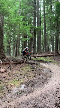
Photos of Randle Mountain Bike
Videos of Randle Mountain Bike
Current Trail Warnings
| status | trail | date | condition | user | info |
|---|---|---|---|---|---|
| Morrison Creek Trail | Sep 16, 2026 @ 10:29pm (America/Los_Angeles) Sep 16, 2026 | Unknown | rlb1618 | Section above Buck Creek overgrown, hard... |
Recent Trail Reports
| status | trail | date | condition | info | user |
|---|---|---|---|---|---|
| Tumwater Peak Trail | Sep 20, 2026 @ 9:52pm (America/Los_Angeles) 2 days | Dry | richardalexlockwood | ||
| Lewis River | Sep 17, 2026 @ 9:59am (America/Los_Angeles) Sep 17, 2026 | Unknown | kite-rider | ||
| Strawberry Ridge | Sep 13, 2026 @ 8:06am (America/Los_Angeles) Sep 13, 2026 | Dry | pizzamouse | ||
| Juniper Ridge | Sep 13, 2026 @ 8:05am (America/Los_Angeles) Sep 13, 2026 | Dry | pizzamouse | ||
| Sunrise Trail | Sep 13, 2026 @ 8:03am (America/Los_Angeles) Sep 13, 2026 | Unknown | pizzamouse | ||
| Tongue Mountain Trail | Sep 13, 2026 @ 8:02am (America/Los_Angeles) Sep 13, 2026 | Unknown | pizzamouse | ||
| Hamilton Buttes | Sep 9, 2026 @ 8:09pm (America/Los_Angeles) Sep 9, 2026 | Dry | jonfrTF | ||
| Goat Creek | Sep 8, 2026 @ 8:54am (America/Los_Angeles) Sep 8, 2026 | Ideal | ckoont | ||
| Goat Mountain | Sep 7, 2026 @ 12:02pm (America/Los_Angeles) Sep 7, 2026 | Ideal | ckoont | ||
| Plains of Abraham | Sep 7, 2026 @ 1:50pm (America/Vancouver) Sep 7, 2026 | Ideal | Mdeniston |
Activity Feed
| username | action | type | title | date |
|---|---|---|---|---|
| charles-71 | comment | trail | activity #104395012 and 1 more | Sep 22, 2026 @ 6:56pm 5 hours |
| dteitleb | wishlist | trail | activity #104277914 | Sep 21, 2026 @ 3:59am 2 days |
| richardalexlockwood | add | report | activity #104268968 | Sep 20, 2026 @ 9:52pm 2 days |
| Casey80Ybct | wishlist | trail | activity #104186457 | Sep 20, 2026 @ 12:09am 3 days |
| Pauld13pdM | ridden | trail | activity #104175662 | Sep 19, 2026 @ 5:42pm Sep 19, 2026 |
Recent Comments
| username | type | title | comment | date |
|---|---|---|---|---|
| trail | Appreciate the comments about whether it's... | Sep 22, 2026 @ 7:01pm 5 hours | ||
| trail | Is this section of trail really open to bikes?... | Sep 22, 2026 @ 6:56pm 5 hours | ||
| report | @gabrielamadeus any info on if this has seen... | Sep 9, 2026 @ 9:23am Sep 9, 2026 | ||
| trail | Rode this as the climb on a loop with... | Sep 7, 2026 @ 8:12pm Sep 7, 2026 | ||
| trail | That's a great description for this section.... | Aug 22, 2026 @ 8:49am Aug 22, 2026 |
Local Badges
-

10 Blue Trails35 awarded -

10 Black Trails3 awarded -

Epic Ride Climb 2k259 awarded -

Climbing 10k Badge50 awarded -

Climbing 100k Badge0 awarded -

Epic Ride Descent 2k344 awarded
Local Trail Supporters
- Cold Creek Mountain Bikers
Activity Type Stats
| activitytype | trails | distance | descent | descent distance | total vertical | rating | global rank | state rank | photos | reports | routes | activity logs |
|---|---|---|---|---|---|---|---|---|---|---|---|---|
| Mountain Bike | 257 | 1,033 miles | 162,178 ft | 423 miles | 5,056 ft | #158 | #60 | 738 | 985 | 20 | 4,509 | |
| E-Bike | 132 | 678 miles | 97,503 ft | 276 miles | 5,056 ft | #98 | #644 | 4 | 609 | 1 | 335 | |
| Gravel Bike | 115 | 567 miles | 51,214 ft | 202 miles | 4,787 ft | #40 | #24 | 1 | 55 | 32 | ||
| Adaptive Bike | 69 | 358 miles | 28,510 ft | 118 miles | 4,659 ft | #22 | #58 | 95 | ||||
| Winter Fat Bike | 3 | 14 miles | 2,418 ft | 5 miles | 3,002 ft | #2,358 | #504 | 13 | 1 | |||
| Horse | 110 | 413 miles | 58,717 ft | 166 miles | 8,852 ft | #40 | #255 | 141 | 1 | 3 | ||
| Hike | 387 | 1,252 miles | 208,399 ft | 521 miles | 11,483 ft | #23 | #24 | 16 | 990 | 35 | 2,246 | |
| Trail Running | 382 | 1,245 miles | 207,887 ft | 520 miles | 11,483 ft | #26 | #21 | 990 | 8 | 401 | ||
| Dirtbike/Moto | 99 | 504 miles | 79,232 ft | 208 miles | 4,951 ft | #24 | #13 | 1 | 211 | 1 | 195 | |
| Observed Trials | 1 | 3 miles | 988 ft | 2 miles | 846 ft | 4 | 4 | |||||
| ATV/ORV/OHV | 18 | 106 miles | 13,550 ft | 43 miles | 4,157 ft | #273 | #99 | 88 | 4 | |||
| Snowmobile | 13 | 115 miles | 12,090 ft | 48 miles | 3,615 ft | #86 | #53 | 2 | ||||
| Snowshoe | 20 | 123 miles | 16,811 ft | 52 miles | 11,263 ft | #161 | #42 | 3 | 37 | |||
| Backcountry Ski | 20 | 122 miles | 13,556 ft | 51 miles | 6,670 ft | #183 | #33 | 2 | 444 |
Frequently Asked Questions
▼
What are the best places to ride in Randle?
Randle has 6 areas to explore for mountain biking. The top rated areas are:
▼
What are the highest rated mountain biking trails in Randle?
The highest rated mountain biking trails in Randle are:
- Ape Canyon Trail (4.6/5)
- Strawberry Ridge (4.6/5)
- Plains of Abraham (4.6/5)
- Goat Mountain (4.5/5)
- Wright Meadow Trail (4.4/5)
▼
What is the best time of the year to ride in Randle?
Based on activity log data, the most popular months to ride in Randle are:
- July (187 activities)
- August (170 activities)
- September (125 activities)
▼
Where can I park to ride in Randle?
There are 90 parking locations listed in Randle. The most popular parking spots are:
- Parking
- Parking
- Marble Mountain Sno-Park
- Climbers Bivouac Trailhead Parking
- South Climb Trailhead Parking
▼
What is the longest trail in Randle?
The longest trail in Randle is Boundary Trail at 24.6 miles. View all trails sorted by distance.
▼
What are the best & highest rated hiking trails in Randle?
The best hiking trails in Randle are:
- Lewis River Trail (Upper)
- Ptarmigan Trail
- Monitor Ridge Summit Trail
- Worm Flows Climbing Route
- South Climb Trail
▼
What are the best & highest rated trail running trails in Randle?
The best trail running trails in Randle are:
- Swift Creek Loop
- Loowit #216: Ape Canyon - Windy
- Loowit #216: Castle Ridge - Sheep Canyon
- June Lake Trail
- Lower Lewis Falls Access Trail
▼
What are the best & highest rated dirtbiking trails in Randle?
The best dirtbiking trails in Randle are: View all dirtbiking trails sorted by popularity score.
▼
How many trails are in Randle?
Randle has a total of 388 trails. Of those, 257 are designated for mountain biking. Browse top mountain biking trails in Randle to find detailed information including difficulty ratings, distances, and trail conditions.
▼
Which trail has the most elevation gain in Randle?
The trail with the most elevation gain in Randle is Boundary Trail with 5,193 ft of elevation gain. View all trails sorted by elevation gain.
▼
Which trail has the most elevation descent in Randle?
The trail with the most elevation descent in Randle is Boundary Trail with 4,438 ft of elevation descent. View all trails sorted by elevation descent.
▼
What activities are most popular in Randle?
Randle supports the following activities: Mountain Biking, E-Biking, Gravel Biking, Adaptive Biking, Winter Fat Biking, Horseback, Hiking, Trail Running, Dirtbiking, ATVing/Offroading, Snowmobiling, Snowshoeing, Backcountry Skiing.
▼
What are the steepest mountain biking trails in Randle?
The steepest mountain biking trail in Randle is Elk Peak Trail with an average grade of 23.7%. View all trails sorted by grade.
▼
Are there any trails with scenic viewpoints in Randle?
Yes, there are 16 scenic viewpoints marked along trails in Randle. Some popular viewpoints include: Explore more points of interest to find trails with the best views.
▼
Are the trails open in Randle?
The overall region status for Randle is Minor Issue / Yellow. Out of 170 trails:
- Clear / Green: 117
- Minor Issue / Yellow: 27
- Significant Issue / Amber: 23
- Closed: 3
▼
What are the trail conditions in Randle?
Based on trail reports from the past week in Randle:
- Dry: 1 trail
▼
Can I ride an ebike in Randle?
Yes, Randle supports e-bike riding. There are 116 trails in Randle that allow e-bikes. Check the e-bike trails listing for specific trail access details and any local regulations.
▼
What are the most popular mountain biking routes in Randle?
The most popular mountain biking routes in Randle are:
- Ape Canyon to Plains of Abraham (IMBA Epic)
- Juniper ridge loop via Dark Meadow
- 2018 Trans-Cascadia Day 1
▼
What type of bike is most common in Randle?
Based on activity log data, the most common bike types used in Randle are:
- AM (87 activities)
- XC (13 activities)
▼
What is the highest summit in Randle?
The highest summit in Randle is North Goat Ridge at 6,781 ft elevation.
▼
What are the top sights to see in Randle?
There are 26 notable sights in Randle. Some of the top sights include:
- Curly Creek Falls
- Upper Lewis River Falls
- Lower Copper Creek Falls
- Upper Copper Creek Falls
- Taitnapum Falls
▼
What are the most popular Strava Segments in Randle?
The most popular Strava segments in Randle are:
- Quickie Fun (3,646 athletes)
- Climb out of the Plains (2,845 athletes)
- Planes of Abraham descend (2,310 athletes)
▼
What are some popular technical trail features in Randle?
There are 3 technical trail features (TTFs) in Randle. Some popular features include: View all technical trail features in Randle.
▼
What trails are closed in Randle?
There are currently 3 closed trails in Randle. The breakdown of all trail statuses is:
- Clear / Green: 117
- Minor Issue / Yellow: 27
- Significant Issue / Amber: 23
- Closed: 3
▼
Are there accessible or adaptive trails in Randle?
Yes, there are 69 accessible/adaptive trails in Randle. View all adaptive trails in Randle for specific accessibility information.
▼
What are the most popular mountain biking trails in Randle?
The most popular mountain biking trails in Randle are:
- Strawberry Mountain Connector
- Ape Canyon Trail
- Boundary Trail
- Plains of Abraham
- Blue Lake Hiker Trail #274
▼
What are the best beginner ride trails in Randle?
The best beginner mountain biking trails in Randle are: View all beginner mountain biking trails in Randle.
Activities
- Randle Mountain Biking Trails
- Randle E-Biking Trails
- Randle Gravel Biking Trails
- Randle Adaptive Biking Trails
- Randle Horseback Trails
- Randle Hiking Trails
- Randle Trail Running Trails
- Randle Dirtbiking Trails
- Randle ATVing/Offroading Trails
- Randle Snowmobiling Trails
- Randle Snowshoeing Trails
- Randle Backcountry Skiing Trails
Trails
Points of Interest
- By garretts
 EMBA-CN & contributors
 - Admins: EMBA-SW
- #24629 - 9,549 views
- randle activity log | embed map of Randle mountain bike trails | randle mountain biking points of interest
Downloading of trail gps tracks in kml & gpx formats is enabled for Randle.
You must login to download files.