close
-
Layers w
- Weather Layers
- Pro
- Pro
- Pro
- Pro
- Pro
- Pro
- More Layers
- Pro
- Pro
- Pro
- Pro
-
Upgrade to

3D
Trail Conditions
- Unknown
- Snow Groomed
- Snow Packed
- Snow Covered
- Snow Cover Partial
- Freeze/thaw Cycle
- Icy
- Prevalent Mud
- Wet
- Variable
- Ideal
- Dry
- Very Dry
Trail Flow (Ridden Direction)
Trailforks scans users ridelogs to determine the most popular direction each trail is ridden. A good flowing trail network will have most trails flowing in a single direction according to their intension.
The colour categories are based on what percentage of riders are riding a trail in its intended direction.
The colour categories are based on what percentage of riders are riding a trail in its intended direction.
- > 96%
- > 90%
- > 80%
- > 70%
- > 50%
- < 50%
- bi-directional trail
- no data
Trail Last Ridden
Trailforks scans ridelogs to determine the last time a trail was ridden.
- < 2 days
- < 1 week
- < 2 weeks
- < 1 month
- < 6 months
- > 6 months
Trail Ridden Direction
The intended direction a trail should be ridden.
- Downhill Only
- Downhill Primary
- Both Directions
- Uphill Primary
- Uphill Only
- One Direction
Contribute Details
Colors indicate trail is missing specified detail.
- Description
- Photos
- Description & Photos
- Videos
Trail Popularity ?
Trailforks scans ridelogs to determine which trails are ridden the most in the last 9 months.
Trails are compared with nearby trails in the same city region with a possible 25 colour shades.
Think of this as a heatmap, more rides = more kinetic energy = warmer colors.
- most popular
- popular
- less popular
- not popular
ATV/ORV/OHV Filter
Max Vehicle Width
inches
US Cell Coverage
Legend

Radar Time
Activity Recordings
Trailforks uses anonymized public activity data.
?
Activity Recordings
Trailforks uses anonymized public activity data.
?
Personal Heatmap
▶
Activity Types
all
/
none
▶
Options
2
Date range
month
–
Winter Trails
Warning
A routing network for winter maps does not exist. Selecting trails using the winter trails layer has been disabled.
Missing Trails
Most Popular
Least Popular
Trails are colored based on popularity. The more popular a trail is, the more red. Less popular trails trend towards green.
Jump Magnitude Heatmap
Heatmap of where riders jump on trails. Zoom in to see individual jumps, click circles to view jump details.
BC Backroad Status
![map legend]()
Service Road Atlas is a free to use, community-driven service for viewing and creating reports on the numerous back-country service roads around B.C. and Alberta.

Slope Aspect
Direction the slope faces
Trails Deemphasized
Trails are shown in grey.
Only show trails with no bike usage.
Suggested Layers
Based on selected activity type
Save the current map location and zoom level as your default home location whenever this page is loaded.
SaveThe place to go for some amazing mountain biking and other outdoor activities. Trails for the whole family, from Downhill at Mt. Bachelor to easy & hard XCountry trails at Phil's.
Activities Click to view
- Mountain Bike
256 trails
- E-Bike
63 trails
- Gravel Bike
1 trails
- Adaptive Bike
0 trails
- Winter Fat Bike
0 trails
- Horse
96 trails
- Hike
369 trails
- Trail Running
369 trails
- Dirtbike/Moto
226 trails
- ATV/ORV/OHV
223 trails
- Snowshoe
48 trails
- Downhill Ski
112 trails
- Backcountry Ski
37 trails
- Nordic Ski
110 trails
Region Details
- 34
- 5
- 89
- 88
- 31
- 4
- 2
Region Status
Open as of 17 hoursStats
- Avg Trail Rating
- Trails (view details)
- 848
- Trails Mountain Bike
- 256
- Trails E-Bike
- 63
- Trails Gravel Bike
- 1
- Trails Horse
- 96
- Trails Hike
- 369
- Trails Trail Running
- 369
- Trails Dirtbike/Moto
- 226
- Trails ATV/ORV/OHV
- 223
- Trails Snowshoe
- 48
- Trails Downhill Ski
- 121
- Trails Backcountry Ski
- 37
- Trails Nordic Ski
- 110
- Total Distance
- 1,788 miles
- Total Descent
- 191,551 ft
- Total Vertical
- 7,594 ft
- Highest Trailhead
- 10,341 ft
- Reports
- 6,291
- Photos
- 1,947
- Ridden Counter
- 303,637
Articles
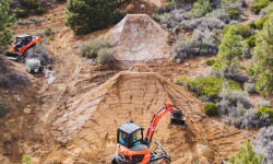
Video: Carson Storch & Cam McCaul Lead Star-Studded Rebuild of Legendary Oregon Jump Line
Jun 2, 2026 from pinkbike.com
In "Building the Dream Vol. 2," a heavy-hitting crew uses heavy machinery to completely revive and "bulletproof" the famous Apollo line at The Lair.
Video: Carson Storch Blends His Passions for Off Roading and Mountain Biking in 'Otherside'
Jan 30, 2025 from pinkbike.com
Fair warning—this one leans heavily into off-roading but is quite rad!

Video: Kyle Jameson Passes his Trail Building Skills to the Next Generation
Nov 20, 2022 from pinkbike.com
Kyle Jameson helps trail alliance, COTA, reshape a local trail.

Oregon's 5 Most Popular Trail Networks According to Trailforks Data
Oct 19, 2021 from pinkbike.com
Oregon is one of the most revered parts of the country amongst the mountain bike community, with riding opportunities that reflect the diverse...
Sub Regions
-
Dutchman Flat Sno-Park
- 1
- 6
-
Edison Butte
- 1
- 2
-
Horse Butte
- 5
-
Horse Ridge
- 2
- 3
- 4
- 1
-
Larkspur
- 1
-
Mt. Bachelor Bike Park
- 2
- 14
- 6
- 1
-
Phil's
- 3
- 39
- 26
- 7
- 2
-
Swampy Sno-Park
- 4
- 7
-
Wango Sno-Park
- 3
- 1
-
Wanoga
- 4
- 13
- 7
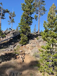
Popular Bend Mountain Biking Trails
• 85 ★ 4.3 • 6 miles • 526 ft • 6,308 •
The easiest loop out of the Welcome Center. Some fun rock features and a beautiful section through the canyon.
• 100 ★ 4.5 • 2 miles • 0 ft • 5,789 •
One of the most fun trails in the area. This trail is fast and fun. Multiple jump options and some that you can get pretty good air on. You can roll all the jumps, but there are some optional lines for some pretty big table tops. Rip...
• 100 ★ 3.6 • 5 miles • 712 ft • 5,230 •
Popular green difficulty singletrack. This mountain bike primary trail can be used one direction and has a moderate overall physical rating with a 712 ft blue climb. Adaptive MTB rating: amtb green. On average it takes 40 minutes to complete this trail.
• 100 ★ 4.4 • 4 miles • 79 ft • 4,748 •
This is the super fun section of Tiddlywinks. Flowy berms and tabletops make for huge grins all around. Nothing scary or technical about this part of the trail, just fun.
• 95 ★ 3.9 • 6 miles • 42 ft • 4,572 •
Most of the trail is downhill only, with the exception of the upper 1/4 which is 2-way from to the top. Super smooth and just flows but you'll have to pedal on some sections to keep your speed up. There is a little rooty section that...
• 100 ★ 3.0 • 961 ft • 2 ft • 4,533 •
This lower section is one big long straight line pump track. Something like 30 hills that you can just pump your bike over.
• 100 ★ 3.9 • 1,535 ft • 99 ft • 4,470 •
A short Uphill Only segment of the . Nothing technical. Takes you to the start of proper.
• 55 ★ 4.0 • 3 miles • 284 ft • 4,317 •
Fun and challenging in both directions with a couple of optional lower speed drops. When riding east on the trail keep your eye out for the roll-able rock drop feature on your right.
Bend Mountain Bike Routes
★ 3.7 • 9 miles • 627 ft • 12 • Loop •
An Easy/Intermediate one way loop starting and ending at Phil's trailhead. This is a great introductory...
★ 5.0 • 13 miles • 1,594 ft • 12 • Loop •
Overview With a doubletrack climb, Tyler’s Traverse is all gain with little pain. Once you start the...
★ 5.0 • 13 miles • 1,542 ft • 3 •
from skyliners take tumalo creek up to swede ridge and back down south fork
★ 5.0 • 12 miles • 829 ft • 3 •
Classic Bend singletrack trail, cross country riding with minimal rocks, through forested area. Trailhead:...
★ 4.4 • 12 miles • 1,346 ft • 2 •
10 Barrel Riding Solo Series (Fall 2020) - Week 1 Short Course
★ 4.0 • 4 miles • 478 ft • 2 •
Cross country style climb up Pinedrops, followed by a flowy descent with jumps on . Repeat this loop as...
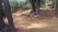
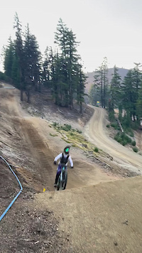
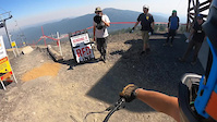
Photos of Bend Mountain Bike
Videos of Bend Mountain Bike
trail: Ponderosa (Pondo)
0:11 |
51 |
Nov 19, 2025
trail: Redline
0:10 |
188 |
Oct 7, 2024

trail: Redline
0:27 |
|
Oct 2, 2024
trail: Tiddlywinks (Upper)
0:10 |
354 |
Jun 3, 2023
trail: Summit East
0:09 |
40 |
Sep 14, 2022
trail: Redline
0:52 |
404 |
Sep 5, 2022
trail: Swamp Wells (South)
0:42 |
155 |
Aug 16, 2022

trail: Phil's (Lower)
0:17 |
123 |
Dec 10, 2021
Current Trail Warnings
| status | trail | date | condition | user | info |
|---|---|---|---|---|---|
| Flagline Access | May 27, 2026 @ 10:33am (America/Los_Angeles) May 27, 2026 | Snow Covered | SHREDMEDGEAR | Logs and considerable snow. Trail all but... | |
| Ramble On | May 24, 2026 @ 11:02am (America/Los_Angeles) May 24, 2026 | Snow Covered | KennyBraun | ||
| Swampy/Dutchman | May 26, 2026 @ 12:15pm (America/Los_Angeles) May 26, 2026 | Prevalent Mud | bendjosh COTA | Closed 7 days a week for logging operations |
Recent Trail Reports
National Scenic Trails & Official Routes
-
Metolius Windigo Trail
- Mountain Bike
- E-Bike
- Horse
- Hike
- Trail Running
Activity Feed
| username | action | type | title | date |
|---|---|---|---|---|
| ray2002 | wishlist | route | activity #96720517 | Jun 10, 2026 @ 11:22pm 3 hours |
| Outdoorgeek | wishlist | route | activity #96717168 | Jun 10, 2026 @ 9:05pm 5 hours |
| Drhumphrey | add | report | activity #96707359 and 1 more | Jun 10, 2026 @ 5:44pm 8 hours |
| mBr3yy | ridden | trail | activity #96705643 | Jun 10, 2026 @ 5:18pm 9 hours |
| Skisumo | add | report | activity #96704258 | Jun 10, 2026 @ 4:55pm 9 hours |
Recent Comments
| username | type | title | comment | date |
|---|---|---|---|---|
| trail | Rode this past weekend. In good shape. Great... | Jun 8, 2026 @ 10:03pm 2 days | ||
| trail | Just rode this past weekend. Great trail, and... | Jun 8, 2026 @ 10:00pm 2 days | ||
| trail | This is a really fun trail and quickly became... | May 19, 2026 @ 10:43am May 19, 2026 | ||
| trail | Probably a black diamond as a climb, but... | May 9, 2026 @ 11:53pm May 9, 2026 | ||
| trail | Currently closed, and generally suffers... | May 9, 2026 @ 11:48pm May 9, 2026 |
Local Badges
-

Top 10 Trails116 awarded -

Descent 100k Badge133 awarded -

Big Ride 30k37,034 awarded -

Epic Ride 50k9,524 awarded -

Completionist0 awarded -
Completionist0 awarded
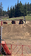
Bike & Skill Parks
| name | type | city | rating |
|---|---|---|---|
| Mt. Bachelor Bike Park | bike park | Bend | |
| Mt Bachelor Ski Resort | bike park | Bend | |
| Wanoga Infield Bike Park Skills Area | skill park | Bend | |
| The Lair | skill park | Bend | |
| Mt. Bachelor Skills Park | skill park | Bend |
Local Products
Activity Type Stats
| activitytype | trails | distance | descent | descent distance | total vertical | rating | global rank | state rank | photos | reports | routes | ridelogs |
|---|---|---|---|---|---|---|---|---|---|---|---|---|
| Mountain Bike | 256 | 491 miles | 51,230 ft | 226 miles | 4,396 ft | #39 | #13 | 1,846 | 6,005 | 205 | 231,882 | |
| E-Bike | 63 | 10 miles | 446 ft | 5 miles | 1,017 ft | #1,125 | #816 | 3 | 4,131 | 2 | 4,899 | |
| Gravel Bike | 1 | #22 | #701 | 11 | 12 | 3 | 1,148 | |||||
| Horse | 96 | 356 miles | 34,288 ft | 155 miles | 7,595 ft | #15 | #310 | 1,033 | 102 | |||
| Hike | 369 | 844 miles | 73,540 ft | 344 miles | 7,595 ft | #31 | #30 | 54 | 5,863 | 1 | 19,824 | |
| Trail Running | 369 | 845 miles | 73,625 ft | 345 miles | 7,595 ft | #29 | #23 | 18 | 5,872 | 3 | 20,287 | |
| Dirtbike/Moto | 226 | 715 miles | 45,574 ft | 311 miles | 3,533 ft | #9 | #5 | 6 | 826 | 281 | ||
| ATV/ORV/OHV | 223 | 707 miles | 43,950 ft | 304 miles | 3,533 ft | #2 | #2 | 824 | 81 | |||
| Snowshoe | 48 | 65 miles | 5,472 ft | 26 miles | 4,088 ft | #25 | #10 | 150 | 799 | |||
| Downhill Ski | 112 | 55 miles | 48,901 ft | 52 miles | 3,110 ft | #56 | #26 | 1 | 46 | 9,185 | ||
| Backcountry Ski | 37 | 46 miles | 3,855 ft | 17 miles | 5,305 ft | #37 | #8 | 1 | 90 | 7,587 | ||
| Nordic Ski | 110 | 119 miles | 11,214 ft | 52 miles | 3,068 ft | #8 | #2 | 11 | 213 | 14,907 |
Frequently Asked Questions About Bend
▼
What are the best places to ride in Bend?
Bend has 27 areas to explore for mountain biking. The top rated areas are:
▼
What are the highest rated mountain biking trails in Bend?
The highest rated mountain biking trails in Bend are:
- Tyler's Traverse (4.5/5)
- 50 Shades of Blue (4.5/5)
- Flagline (Middle) (4.4/5)
- Whoops (Lower) (4.4/5)
- Funner DH (4.4/5)
▼
What is the best time of the year to ride in Bend?
Based on ride log data, the most popular months to ride in Bend are:
- July (4,797 activities)
- June (3,539 activities)
- August (3,420 activities)
▼
Where can I park to ride in Bend?
There are 124 parking locations listed in Bend. The most popular parking spots are: View all parking and trailhead locations on the map to plan your visit.
Activities
Trails
Points of Interest
- Tumalo Falls Viewpoint
- Reservoir Road Play Area TTF
- Cinder Pit Play Area TTF
- ODOT Pit Play Area TTF
- Kwohl Butte Shelter Cabin
- Sheridan Mountain Shelter Cabin
- Mt Bachelor - North Viewpoint
- Mt Bachelor - South Viewpoint
- Wake Butte Summit
- Rainbow Falls Sight
- Hodge Crest (10,033 ft)
- Broken Hand (8,363 ft)
- Ball Butte (8,087 ft)
- By canadaka
 Trailforks & contributors
 - Admins: COTA, COTA, COTA
- #3296 - 186,754 views
- bend activity log | embed map of Bend mountain bike trails | bend mountain biking points of interest polygons
Downloading of trail gps tracks in kml & gpx formats is enabled for Bend.
You must login to download files.