more stats
1.3 miles
Distance
168 ft
Climb
-180 ft
Descent
00:16:31
Avg time
-12 ft
Altitude change
4,245 ft
Altitude min
4,336 ft
Altitude max
4,265 ft
Altitude start
4,252 ft
Altitude end
-0.2%
Grade
-24.2%
Grade max
34.3%
Grade min
2,487 ft
Distance climb
2,861 ft
Distance down
1,444 ft
Distance flat
00:16:31
Avg time

Sketch Details

  • Activities
    • Mountain Bike
    • Hike
    • Trail Running
  • Riding Area
    Carroll Canyon
    Sedona, Arizona
  • Ref Number
    #672
  • Difficulty Rating
  • Voted Difficulty
    Black Diamond (2 votes)
  • Local Popularity
    65 in Mountain Biking [+]
    • 75 in Trail Running
    • 65 in Hiking
  • Global Ranking
    #9564 in Mountain Biking [+]
    • #81929 in Trail Running
    • #81315 in Hiking
  • Trail Type
    Singletrack
  • Bike Type
    AM
  • Direction
    Both Directions
  • Climb Difficulty
    Black Diamond
  • Physical Rating
    Hard
  • Season
    All Year
  • Dogs Allowed
    Yes
  • eBike Allowed
  • TTFs on Trail
    Berm
  • Ride in Rain
    Yes
  • Land Owner
    USFS

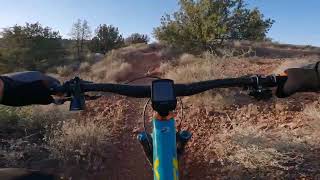
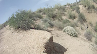
The newly adopted Sketch trail has been a long term favorite of the local Sedona mountain bike community. The FS has recently done several re-routes to make the trail more user friendly to advanced/intermediate riders. The trail is rated as 75% intermediate, 20% advanced and 5% advanced with exposure. The trail is easiest to ride from north to south mostly downhill direction. The south to north direction is totally rideable by more experienced riders who like narrow challenging uphill trails.

One of the nice characteristics of the trail is that it can be ridden after 3 or 4 hours of clear weather after heavy rain periods due to the rocky nature of the trail tread. This trail is also very scenic and offers great views of the major rock formations (Cathedral Pyramid,, Thunder Mountain, Bell Rock and Courthouse) surrounding Sedona. There is a special break spot about halfway through the ride with a great view of the Carroll Canyon wash several hundred feet below. There are some berms on several turns to allow for a faster ride in those sections.

Since Sketch intersects the Ridge trail at the north and south ends it offers and optional route between the Chavez gravel road (south end) and the Recycle Center (north end). For advanced riders that have good climbing skills and don't mind some exposure, Sketch is a much more enjoyable ride in the south to north direction.

Access Info

The Sketch trail intersects the Ridge trail which starts at the Recycle Center at the north end or Chavez gravel road at the south end.

Disclaimer

Equestrians Restricted

Trail Supporters

  • USFS
    Land Manager
Local Trail Association

Recent Activity on Trail

Past Week
  • 1 rides
  • 12.4 km average
6 Months
  • 59 rides
  • 31.9 km avg distance
All
  • 458 rides
  • Last: Jun 28, 2026
c1c2c3c4
January
February
March
April
May
June
July
August
September
October
November
December
Status:
on May 13, 2025
Dry
Avg: 4.08 (20 votes)
Your vote: 0

view (2,427)
close
3D
Trail Conditions
  • Unknown
  • Snow Groomed
  • Snow Packed
  • Snow Covered
  • Snow Cover Partial
  • Freeze/thaw Cycle
  • Icy
  • Prevalent Mud
  • Wet
  • Variable
  • Ideal
  • Dry
  • Very Dry
Trail Flow (Ridden Direction)
Trailforks scans users ridelogs to determine the most popular direction each trail is ridden. A good flowing trail network will have most trails flowing in a single direction according to their intension.
The colour categories are based on what percentage of riders are riding a trail in its intended direction.
  • > 96%
  • > 90%
  • > 80%
  • > 70%
  • > 50%
  • < 50%
  • bi-directional trail
  • no data
Trail Last Ridden
Trailforks scans ridelogs to determine the last time a trail was ridden.
  • < 2 days
  • < 1 week
  • < 2 weeks
  • < 1 month
  • < 6 months
  • > 6 months
Trail Ridden Direction
The intended direction a trail should be ridden.
  • Downhill Only
  • Downhill Primary
  • Both Directions
  • Uphill Primary
  • Uphill Only
  • One Direction
Contribute Details
Colors indicate trail is missing specified detail.
  • Description
  • Photos
  • Description & Photos
  • Videos
Trail Popularity ?
Trailforks scans ridelogs to determine which trails are ridden the most in the last 9 months. Trails are compared with nearby trails in the same city region with a possible 25 colour shades. Think of this as a heatmap, more rides = more kinetic energy = warmer colors.
  • most popular
  • popular
  • less popular
  • not popular
ATV/ORV/OHV Filter
Max Vehicle Width
inches
US Cell Coverage
Legend
cell carrier legend

Radar Time
Activity Recordings
Trailforks uses anonymized public activity data. ?
Activity Recordings
Trailforks uses anonymized public activity data. ?
Personal Heatmap
Activity Types
all / none
Options
2
Date range month
Winter Trails
Warning A routing network for winter maps does not exist. Selecting trails using the winter trails layer has been disabled.
Missing Trails
Most Popular
Least Popular
Trails are colored based on popularity. The more popular a trail is, the more red. Less popular trails trend towards green.
Jump Magnitude Heatmap
Heatmap of where riders jump on trails. Zoom in to see individual jumps, click circles to view jump details.
BC Backroad Status

Service Road Atlas is a free to use, community-driven service for viewing and creating reports on the numerous back-country service roads around B.C. and Alberta.

map legend
Slope Aspect
Direction the slope faces
Flat N NE E SE S SW W NW
Trails Deemphasized
Trails are shown in grey.
disable
Only show trails with no bike usage.
Enable
Suggested Layers
Based on selected activity type

    Save the current map location and zoom level as your default home location whenever this page is loaded.

    Save
        Directions to sketch trailhead (34.842430, -111.802640)

        Photos

        33 more »
        306 |
        Jan 7, 2016 @ 7:39pm
        Jan 7, 2016
        261 |
        Jan 7, 2016 @ 7:35pm
        Jan 7, 2016
        35 |
        Mar 17, 2026 @ 8:54pm
        Mar 17, 2026
        81 |
        Oct 29, 2022 @ 5:53pm
        Oct 29, 2022

        Videos

        3 more »
        youtuber Ridge & Sketch
        9:52 | 193 | Oct 27, 2023 , Sedona
        Sketch
        10:43 | 182 | Aug 28, 2022 , Sedona
        Sketch
        0:06 | 508 | Apr 28, 2014 , Sedona

        Routes with this trail

        5.0 37 miles 5,341 ft 20 Loop
        Triple H has a new sibling. This ride combines four of the most technical trails in Sedona: Hardline,...
        5.0 10 miles 1,120 ft 7 Loop
        is a less used trail system in Sedona, but several of the trails make it worth exploring - the Triple- : ,...
        5.0 53 miles 5,619 ft 24
        This is for the AES BFL for the year 2021

        5 Reviews & Comments


        We hope you've been enjoying Trailforks!

        Create a FREE account to view trail comments and much more.

        Nearby Trails

        • By johnf0246TF Pro & contributors
        • #46180 - 6,492 views

        Frequently Asked Questions About Sketch

        Where is Sketch located?
        Sketch is located in Carroll Canyon, Sedona, Arizona, United States. It is part of the Carroll Canyon trail network. The trailhead is located at coordinates 34.84243, -111.80264.
        How hard is Sketch?
        Sketch is rated as Black Diamond difficulty. The physical rating is Hard. The average grade is 0.2%. The climb difficulty is rated Black Diamond.
        What is the elevation gain for Sketch?
        Sketch has 168 ft of elevation gain. The trail has 180 ft of elevation descent. The elevation ranges from 4,245 ft to 4,336 ft.
        Is Sketch a point to point trail?
        Sketch is not a point to point trail. The direction is Both Directions. The trail type is singletrack.

        Hit the Trail

        Open in App

        Get this trail on your phone instantly.
        open trail in app

        Download Trail

        Save to wishlist, Garmin & download.
        save the trail

        Find Related Routes

        Find routes and users activities that include this trail.
        find routes for this trail

        You must enter a description before submitting.