Trailforks is a trail database, map & management system for users, builders and associations.


The largest trails database and the authoritative source for trail information for many regions around the world. A platform for trail associations to keep track of trail conditions, builders to log work & users to discover, plan and share their activities.
Trailforks is dedicated to giving you the best interactive trail maps, custom designed for your selected activity. Trailforks is unlike other mapping apps, we focus on trails & build our own maps from data contributed by our users, trail associations & staff.
Topographic layer, points of interest, trail popularity, heatmaps, routes, trail conditions, Strava segments, photos, videos and so much more. Our Map empowers you with the info you need to navigate trail networks, so you won't be scared of getting lost.
Trailforks is world-wide with trails mapped in over 100 countries. Track your activities to contribute trail usage data back to the outdoor community.
Try Trailforks For Free

The Trailforks map and content change based on your selected activity type context.
-
Layers w
- Weather Layers
- Pro
- Pro
- Pro
- Pro
- Pro
- Pro
- More Layers
- Pro
- Pro
- Pro
- Pro
-
Upgrade to

- Unknown
- Snow Groomed
- Snow Packed
- Snow Covered
- Snow Cover Partial
- Freeze/thaw Cycle
- Icy
- Prevalent Mud
- Wet
- Variable
- Ideal
- Dry
- Very Dry
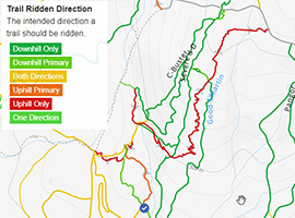
The colour categories are based on what percentage of riders are riding a trail in its intended direction.
- > 96%
- > 90%
- > 80%
- > 70%
- > 50%
- < 50%
- bi-directional trail
- no data
- < 2 days
- < 1 week
- < 2 weeks
- < 1 month
- < 6 months
- > 6 months
- Downhill Only
- Downhill Primary
- Both Directions
- Uphill Primary
- Uphill Only
- One Direction
- Description
- Photos
- Description & Photos
- Videos
- most popular
- popular
- less popular
- not popular

Service Road Atlas is a free to use, community-driven service for viewing and creating reports on the numerous back-country service roads around B.C. and Alberta.

Save the current map location and zoom level as your default home location whenever this page is loaded.
SaveSave the current map location and zoom level as your default home location whenever this page is loaded.
Save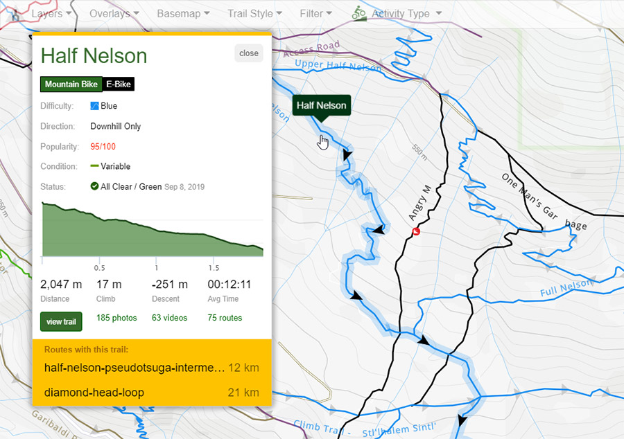
Whether you're at home or travelling, find your perfect bike, hike, moto or horse trail. We collect a wide-array of metadata about trails such as it's difficulty, surface type, direction, ttfs, season, allowed activity types and much more.
View photos & videos of trails including POV from your favorite Youtuber.
Filter the map to only show trails you're interested in. Easily understand what trails you are allowed to use for your selected activity. View trails color coded for popularity, condition, recent usage, direction & more.
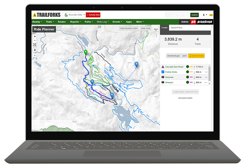
Route Planner
Use our Route Planner to drag & drop routes along mountain bike, hiking, skiing & moto trails.
Save your plan then sync it in your app under "My Wishlist".
View our Weather Map to find the best area to visit given the forecast.
Route Finder
Our visual Route Finder helps you find routes on the map, filtered by the criteria you want. Also find popular curated routes and race courses.
We scan millions of user activities to programmatically determine the most popular routes people use in each area.
Share Routes
Send a route or Route Plan URL to a friend, or scan a QR Code. When opened on a phone it will load the route in the Trailforks app!
"Wishlist" a route to sync a route to your apps routes tab under "My Routes".
Trailforks is much more than a map & trail guide. It's an entire trail management system for trail associations & builders.
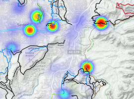
We scan millions of activity logs to calculate the most popular trails in each region. They are then color coded red to green on the popularity "trail style" layer. View activities heatmap or our "Activity Recordings" to increase the accuracy of mapped trails gps track.
View major US & Canadian land owners overlayed on the map, such as USFS, BLM & Wilderness areas. Custom local land owners and polygons can also be added.
Features like our 'ride starting point heatmap' to plan trail-heads, or trail direction & flow visualizations.
Post your events to our calendar including races. Plan race routes using our route planner tool. Print race course maps using our print tool.
We have over 20 customizable widgets you can add to your clubs website. RSS feeds or export trail data in various formats, including work report summary spreadsheets.
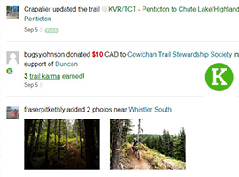
Donate directly to the local trail associations via our Trail Karma feature. We have the largest directory of trail associations and bike shops.
Users can check a trail networks current trail status before heading out on a ride/hike/ski, to avoid closed trails or trails with major issues.
After an activity they can report the trail conditions or any issues on the trails they rode.
Builders and associations can monitor the reports for issues that require action and send someone out to check or fix the issue and report that work done.
Read more about our robust reporting features!
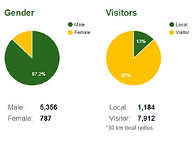
Activity Log data from users is matched against trails generating a virtual trail counter. Statistics with demographic info is generated for trails & regions, which can be a valuable tool for trail advocacy & planning.
Use a single map platform for all your regions trails for all their supported activities, including a seperate winter map mode.
Promote trail supporters or stewards on trail & region pages to power local adopt-a-trail type programs.
Keep tabs to what content is being added or edited for entire countries or states, local areas or specific trails. Subscribe to regions or trails to be notified when new content is added.
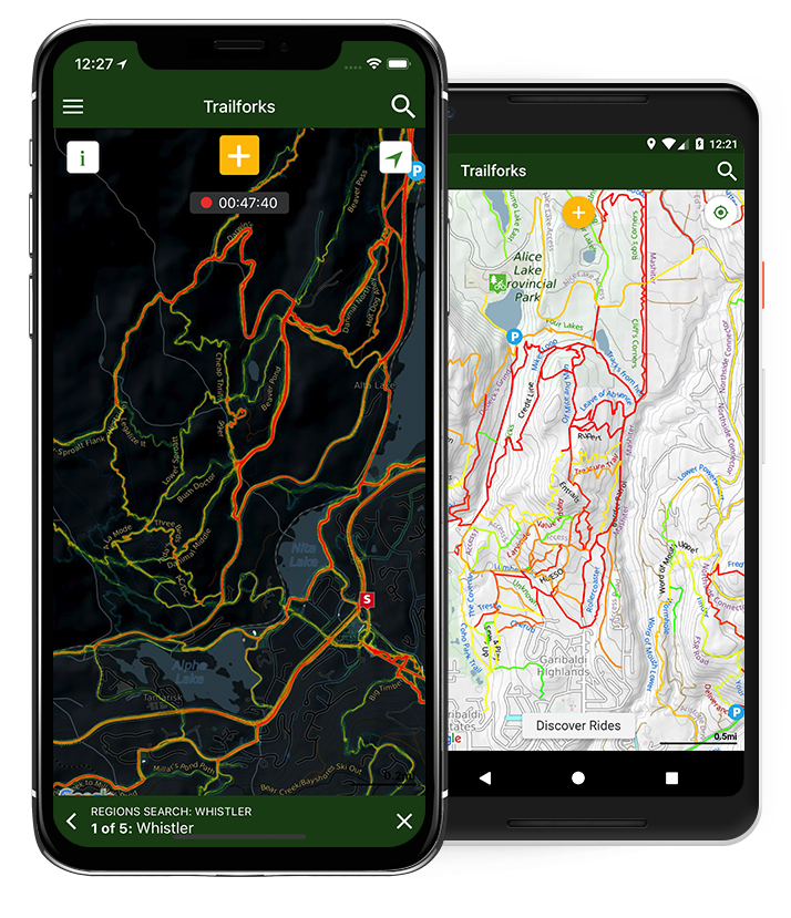
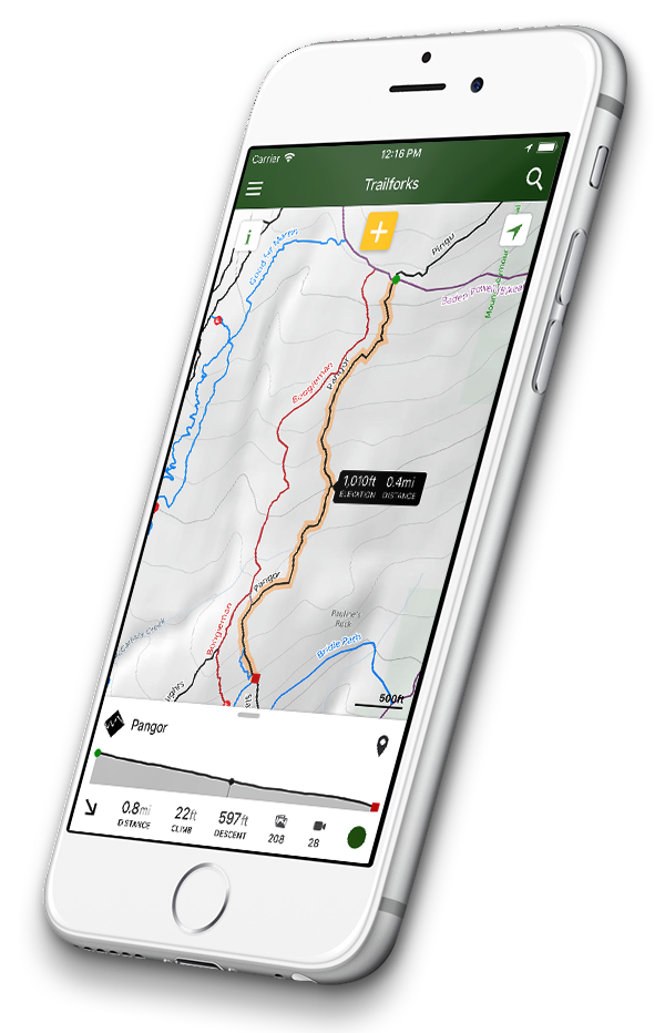
Download offline trail maps for your activities. Record your activities. Always have the latest trail info including trail conditions in your pocket!
Have a Garmin Edge device? Download our Custom MTB Garmin maps.
Or buy an Edge 530 or 830 to get the Trailforks pre-loaded on the device!
Upcoming Events
-
-
WHEELS IN VALLEYFestivalBarzio
-
-
-
-
Marcha Merindades BikeGroup RideMedina De Pomar
Browse Popular Trails
-
- KirkfordNorth Vancouver BC
-
-
- Heartbreak RidgeBallater
-
-
- Cressy DescentYou Yangs
-
-
- Hawk EyeEast Burke VT
-
-
- Chicken RunAuckland
-
-
- Tracks from HellSquamish BC
-
-
- Soft YoghurtCanmore AB
-
-
- ChiplineBrisbane
-
-
- Dougie Bank (Blue,...Peebles
-
-
- Stand High Patrol - LowerAvoriaz
-
-
- Base NatoFinale Ligure
-
-
- GoannaGold Coast
-
-
- AntennentrailZürich
-
-
- Braggin RightsBragg Creek AB
-
-
- PapparazziCanberra
-
Browse Popular Cities
- Austin TrailsTX, United States
- Bellingham TrailsWA, United States
- Bend TrailsOR, United States
- Bentonville TrailsAR, United States
- Boise TrailsID, United States
- Brisbane TrailsAustralia
- Calgary TrailsAB, Canada
- Canberra TrailsAustralia
- Colorado Springs TrailsCO, United States
- Draper TrailsUT, United States
- East Burke TrailsVT, United States
- Issaquah TrailsWA, United States
- Las Vegas TrailsNV, United States
- Lithia TrailsFL, United States
- Moab TrailsUT, United States
- North Vancouver TrailsBC, Canada
- Northwest Edmonton TrailsAB, Canada
- Oro-Medonte TrailsON, Canada
- Pamplona TrailsSpain
- Park City TrailsUT, United States
- Phoenix TrailsAZ, United States
- Prescott TrailsAZ, United States
- San Diego TrailsCA, United States
- Scottsdale TrailsAZ, United States
- Squamish TrailsBC, Canada
- Sunrise TrailsFL, United States
- Toronto TrailsON, Canada
- Truckee TrailsCA, United States
- Uxbridge TrailsON, Canada
- Whistler TrailsBC, Canada
Blog
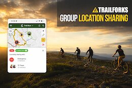 Trailforks Launches Group Location Sharing - Track Your Crew & Stay Safe On Trail
 Jungle Loam & Desert Descents: Inside the Into The Gnar Oaxaca Expedition
Content Stats
- 353,772,526checkins
- 111,056,822activities
- 4,515,850reports
- 1,108,096photos
- 848,160trails
- 179,383videos
- 178,885poi
- 58,472routes
- 27,175trail networks
- 16,770events
- 15,812places
- 6,240skillparks
- 3,050polygons
- 796bikeparks
- 177products
Try Trailforks For Free

- Unlimited access to offline trail maps worldwide in the app
- Every feature Trailforks has to offer
- Gaia GPS Premium membership
- 600+ hours of adventure films & series
- Full access to digital content from Pinkbike, Backpacker, Trail Runner, and every publication in the Outside Network
- Access to expert-led instruction videos with Outside Learn