close
-
Layers w
- Weather Layers
- Pro
- Pro
- Pro
- Pro
- Pro
- Pro
- More Layers
- Pro
- Pro
- Pro
- Pro
-
Upgrade to

3D
Trail Conditions
- Unknown
- Snow Groomed
- Snow Packed
- Snow Covered
- Snow Cover Partial
- Freeze/thaw Cycle
- Icy
- Prevalent Mud
- Wet
- Variable
- Ideal
- Dry
- Very Dry
Trail Flow (Ridden Direction)
Trailforks scans users activity logs to determine the most popular direction each trail is ridden. A good flowing trail network will have most trails flowing in a single direction according to their intension.
The colour categories are based on what percentage of users are riding a trail in its intended direction.
The colour categories are based on what percentage of users are riding a trail in its intended direction.
- > 96%
- > 90%
- > 80%
- > 70%
- > 50%
- < 50%
- bi-directional trail
- no data
Trail Last Ridden
Trailforks scans activity logs to determine the last time a trail was ridden.
- < 2 days
- < 1 week
- < 2 weeks
- < 1 month
- < 6 months
- > 6 months
Trail Ridden Direction
The intended direction a trail should be ridden.
- Downhill Only
- Downhill Primary
- Both Directions
- Uphill Primary
- Uphill Only
- One Direction
Contribute Details
Colors indicate trail is missing specified detail.
- Description
- Photos
- Description & Photos
- Videos
Trail Popularity ?
Trailforks scans activity logs to determine which trails are ridden the most in the last 9 months.
Trails are compared with nearby trails in the same city region with a possible 25 colour shades.
Think of this as a heatmap, more activities = more kinetic energy = warmer colors.
- most popular
- popular
- less popular
- not popular
ATV/ORV/OHV Filter
Max Vehicle Width
inches
US Cell Coverage
Legend

Radar Time
Activity Recordings
Trailforks uses anonymized public activity data.
?
Activity Recordings
Trailforks uses anonymized public activity data.
?
Personal Heatmap
▶
Activity Types
all
/
none
▶
Options
2
Date range
month
–
Winter Trails
Warning
A routing network for winter maps does not exist. Selecting trails using the winter trails layer has been disabled.
Missing Trails
Most Popular
Least Popular
Trails are colored based on popularity. The more popular a trail is, the more red. Less popular trails trend towards green.
Jump Magnitude Heatmap
Heatmap of where users jump on trails. Zoom in to see individual jumps, click circles to view jump details.
BC Backroad Status
![map legend]()
Service Road Atlas is a free to use, community-driven service for viewing and creating reports on the numerous back-country service roads around B.C. and Alberta.

Slope Aspect
Direction the slope faces
Trails Deemphasized
Trails are shown in grey.
Only show trails with no bike usage.
Suggested Layers
Based on selected activity type
Save the current map location and zoom level as your default home location whenever this page is loaded.
SavePopular Trail Networks
view all areas »
No description for Panhandle has been added yet!
Login or register to submit one.
Region Details
- 166
- 14
- 180
- 418
- 144
- 15
- 5
Local Trail Association
Stats
- Avg Trail Rating
- Trails (view details)
- 2,067
- Trails Mountain Bike
- 944
- Trails E-Bike
- 378
- Trails Gravel Bike
- 600
- Trails Adaptive Bike
- 141
- Trails Winter Fat Bike
- 47
- Trails Horse
- 244
- Trails Hike
- 961
- Trails Trail Running
- 948
- Trails Dirtbike/Moto
- 800
- Trails Observed Trials
- 8
- Trails ATV/ORV/OHV
- 405
- Trails Snowmobile
- 17
- Trails Snowshoe
- 83
- Trails Downhill Ski
- 314
- Trails Backcountry Ski
- 40
- Trails Nordic Ski
- 48
- Total Distance
- 4,496 miles
- Total Descent
- 1,065,597 ft
- Total Vertical
- 7,735 ft
- Highest Trailhead
- 8,466 ft
- Reports
- 6,333
- Photos
- 2,606
- Completed Counter
- 135,041
Articles
Registration is Open for the 2026 North American Enduro Cup
Feb 18, 2026 from pinkbike.com
This burly race also doubles as the USA Cycling Enduro & E-Enduro National Championship.
The Fastest Growing Mountain Towns in America
Nov 24, 2025 from outsideonline.com
The mountain states of America hold within them some of the fastest growing towns in the country. Here they are.

Details Announced for the 2026 North American Enduro Cup
Aug 7, 2025 from pinkbike.com
The race offers a $12,000 pro purse with equal payouts.

Race Report: 2025 North American Enduro Cup & Enduro/E-Enduro US National Championships
Jun 27, 2025 from pinkbike.com
Riders from across the continent descended on Silver Mountain Resort in Kellogg, Idaho, for two days of racing last weekend.
Sub Regions
- Bonner County (264)
- Clark Fork (60)
- Coeur d'Alene Mountains (24)
- Scotchman Peaks (24)
- Lakeview (27)
- Gold Creek (27)
- Sagle (16)
- Sandpoint (173)
- Gold Hill (29)
- Lower Basin Trails (27)
- Mineral Point (9)
- Schweitzer (38)
- Syringa Trail System (21)
- Upper Basin (20)
- Clark Fork (60)
- Boundary County (44)
- Bonners Ferry (43)
- Enchanted Forest (5)
- Kaniksu National Forest (13)
- Riverside Park (4)
- Section 16 (6)
- Moyie Springs (0)
- Naples (11)
- Bonners Ferry (43)
- Clearwater County (66)
- Idaho County (17)
- Grangeville (2)
- Kooskia (18)
- Riggins (0)
- Grangeville (2)
- Kootenai County (115)
- Athol (29)
- Bernard Peak (2)
- Farragut State Park (25)
- Coeur d'Alene (86)
- Blue Creek (0)
- Cancourse (11)
- Canfield Mountain Trail System (47)
- Lost Creek (3)
- Mt Coeur D Alene (16)
- Plummer (4)
- Rathdrum (13)
- Spirit Lake (11)
- Empire Trails (8)
- Athol (29)
- Latah County (129)
- Moscow (128)
- Feather Creek (2)
- Little Boulder (2)
- Moscow Mountain (94)
- Palouse Divide (27)
- Potlatch (27)
- Moscow (128)
- Silver Valley (144)
- Kellogg (90)
- Capital Hill (6)
- Graham Mountain (5)
- Silver Mountain Resort (61)
- Mullan (37)
- Murray (17)
- Wallace (1)
- Kellogg (90)
- Avery (5)
- Cottonwood (0)
- Hayden (6)
- English Point (3)
- Herrick (17)
- St. Joe River (10)
- Lewiston (64)
- Craig Mountain (26)
- Hells Gate (19)
- Skinner Canyon (18)
- Nordman (1)
- Post Falls (17)
- Priest River (17)
- Priest Lake (13)
- St Maries (21)
- Marble Creek (17)
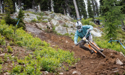
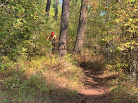
Popular Panhandle Mountain Biking Trails
• 100 ★ 4.5 • 2,749 ft • 2 ft • 1,658 •
Highly rated popular green difficulty singletrack. This mountain bike primary trail can be used downhill primary and has a easy overall physical rating. On average it takes 3 minutes to complete this trail.
• 95 ★ 4.6 • 1,834 ft • 0 ft • 1,598 •
Highly rated popular blue difficulty singletrack. This mountain bike primary trail can be used downhill primary and has a moderate overall physical rating. On average it takes 3 minutes to complete this trail.
• 100 ★ 4.7 • 3,786 ft • 11 ft • 1,563 •
Flowy, with banked turns and great dirt. This trail is an absolute blast when the dirt is damp.
• 100 ★ 3.8 • 1,816 ft • 0 ft • 1,520 •
Popular green difficulty dirt/gravel road. This mountain bike primary trail can be used downhill primary and has a easy overall physical rating. On average it takes 1 minutes to complete this trail.
• 90 ★ 4.4 • 2 miles • 0 ft • 1,467 •
Short trail section provides the option for riders on Wide Open to merge onto before entering the Jumps
• 95 ★ 4.4 • 4,915 ft • 0 ft • 1,430 •
Highly rated popular blue difficulty machine groomed. This mountain bike primary trail can be used downhill only and has a moderate overall physical rating. It features drop and jump. On average it takes 4 minutes to complete this trail.
• 80 ★ 4.5 • 1,890 ft • 0 ft • 1,288 •
A classic Silver Mountain flow trail that winds it's way through some amazing dirt. There are some small jumps that you can link together and a great variety of berms.
• 85 ★ 4.4 • 2,638 ft • 7 ft • 1,287 •
Highly rated popular blue difficulty singletrack. This mountain bike primary trail can be used downhill only and has a moderate overall physical rating. On average it takes 2 minutes to complete this trail.
Panhandle Mountain Bike Routes
★ 4.2 • 5 miles • 1,299 ft • 3 • Loop •
A simple loop of LaFortunes with mostly singletrack. Stars at Warnick Parking, Climbs to . to Four Corners...
★ 5.0 • 168 miles • 5,328 ft • 3 • Loop •
Let me start by saying that I am not a “Roadie”. There was a time when I would rather eat worms than...
★ 5.0 • 3 miles • 490 ft • 5 • Loop •
Starting from VTT to the uphill climb on Green Heart connecting to Momentum to the new Zen Garden trail...
★ 5.0 • 18 miles • 2,596 ft • 13 •
A great ride to do on the Fall Fest Weekend, need a shuttle to get to teh ski hill start
7 miles • 1,328 ft • 3 • Loop •
Route loops up down. Opposite direction fun too.
★ 4.0 • 11 miles • 2,166 ft • 5 • Loop •
Excellent tour of some of the better trails on Canfield Mountain Trail System. Great views of both Hayden...
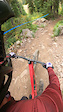
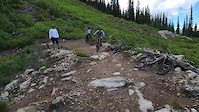
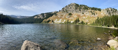
Photos of Panhandle Mountain Bike
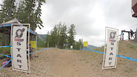
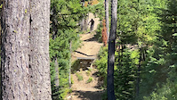
Videos of Panhandle Mountain Bike
trail: Silver Mountain Gondola
0:25 |
28 |
Sep 21, 2025
2:07 |
8 |
Sep 9, 2025

trail: Extraterrestrial
0:03 |
61 |
Jul 2, 2025

trail: Trail 257
0:09 |
70 |
Aug 22, 2024
trail: El Burro Loco
3:09 |
61 |
Nov 22, 2023
trail: Shenanigans
0:15 |
|
Jul 16, 2023

trail: Mutton Conductor
3:41 |
1192 |
Jun 22, 2023
trail: Franknbeans
0:09 |
208 |
Sep 5, 2022
Current Trail Warnings
| status | trail | date | condition | user | info |
|---|---|---|---|---|---|
| Trail 257 South Mt Coeur D Alene | Jul 15, 2026 @ 3:47pm (America/Los_Angeles) Jul 15, 2026 | Ideal | TwistedDewd | Many trees down at the bottom. Not worth... | |
| Kootenai Point Trail Kaniksu National Forest | Jul 13, 2026 @ 9:26am (America/Los_Angeles) Jul 13, 2026 | Dry | joetingstad | 7/11 - Rode up Snow Creek/Kootenai Ridge... | |
| Highpoint Trail Farragut State Park | Jul 12, 2026 @ 11:43am (America/Los_Angeles) Jul 12, 2026 | Unknown | bennettdarren | three trees down [one requires a... |
Recent Trail Reports
National Scenic Trails & Official Routes
-
Idaho Centennial Trail
- Mountain Bike
- Hike
- Trail Running
-
Pacific Northwest Trail
- Mountain Bike
- Horse
- Hike
- Trail Running
Activity Feed
| username | action | type | title | date |
|---|---|---|---|---|
| kellan-hayes | wishlist | route | activity #99726991 and 1 more | Jul 21, 2026 @ 10:27pm 20 hours |
| Hx5iD4 | wishlist | trail | activity #99726177 | Jul 21, 2026 @ 9:52pm 20 hours |
| Lorinevin8 | wishlist | route | activity #99697293 | Jul 21, 2026 @ 11:59am 1 day |
| just-another-basic-bitch | add | photo | activity #99689892 | Jul 21, 2026 @ 10:24am 1 day |
| alexanderacereece | add | report | activity #99686318 | Jul 21, 2026 @ 9:37am 1 day |
Recent Comments
| username | type | title | comment | date |
|---|---|---|---|---|
| trail | Rode on July 20th, only one large tree in the... | Jul 21, 2026 @ 9:36am 1 day | ||
| trail | Skip this one and do Coal Creek as an out and... | Jul 20, 2026 @ 4:15pm 2 days | ||
| trail | This is a horse/moto trail and if you like... | Jul 20, 2026 @ 4:12pm 2 days | ||
| trail | If you ain’t hiking you ain’t biking. I... | Jul 19, 2026 @ 1:10pm Jul 19, 2026 | ||
| trail | Still not passable | Jul 19, 2026 @ 9:09am Jul 19, 2026 |
Local Badges
-

Epic Ride 50k147 awarded -

Descent 100k Badge0 awarded -

Big Ride 30k8 awarded -
Epic Ride 50k40 awarded -
Descent 100k Badge0 awarded -
Epic Ride 50k7 awarded
Bike & Skill Parks
| name | type | city | rating |
|---|---|---|---|
| Silver Mountain Resort | bike park | Kellogg | |
| Schweitzer | bike park | Sandpoint | |
| Lookout Pass Bike Park | bike park | Mullan | |
| Panhandle Bike Ranch | bike park | Sagle | |
| Silver Mountain Ski Resort | bike park | Kellogg |
Local Trail Supporters
- lake city trail builders
![Rails to Trails]()
![Nat. Rec. Trail]()
![ICT]()
![USFS]()
- Selkirk Recreation District
![]()
- MAMBA
- Stimson Lumber Company
- Schweitzer Mountain Resort
![Lewis and Clark Trail]()
![Pacific Northwest]()
![Nez Perce NHT]()
Activity Type Stats
| activitytype | trails | distance | descent | descent distance | total vertical | rating | global rank | state rank | photos | reports | routes | activity logs |
|---|---|---|---|---|---|---|---|---|---|---|---|---|
| Mountain Bike | 944 | 2,675 miles | 555,095 ft | 1,269 miles | 6,736 ft | 2,391 | 6,270 | 89 | 98,209 | |||
| E-Bike | 378 | 1,224 miles | 243,130 ft | 580 miles | 6,722 ft | 45 | 4,585 | 24 | 5,619 | |||
| Gravel Bike | 600 | 1,827 miles | 244,150 ft | 783 miles | 7,339 ft | 578 | 9 | 621 | ||||
| Adaptive Bike | 141 | 630 miles | 64,429 ft | 247 miles | 5,883 ft | 609 | 1 | 8 | ||||
| Winter Fat Bike | 47 | 266 miles | 24,400 ft | 115 miles | 5,656 ft | 136 | 32 | |||||
| Horse | 244 | 1,032 miles | 204,862 ft | 463 miles | 6,801 ft | 5 | 988 | 3 | 17 | |||
| Hike | 961 | 2,769 miles | 539,035 ft | 1,254 miles | 7,736 ft | 114 | 5,848 | 27 | 12,444 | |||
| Trail Running | 948 | 2,758 miles | 536,115 ft | 1,250 miles | 7,736 ft | 16 | 5,841 | 23 | 8,753 | |||
| Dirtbike/Moto | 800 | 2,413 miles | 559,226 ft | 1,170 miles | 6,716 ft | 26 | 931 | 2 | 257 | |||
| Observed Trials | 8 | 37 miles | 3,497 ft | 15 miles | 2,251 ft | 46 | 27 | |||||
| ATV/ORV/OHV | 405 | 1,125 miles | 169,695 ft | 510 miles | 6,568 ft | 880 | 2 | 46 | ||||
| Snowmobile | 17 | 125 miles | 11,401 ft | 52 miles | 3,688 ft | 16 | 18 | |||||
| Snowshoe | 83 | 134 miles | 16,230 ft | 56 miles | 3,524 ft | 213 | 2 | 337 | ||||
| Downhill Ski | 314 | 114 miles | 109,590 ft | 104 miles | 2,953 ft | 7 | 14 | 6,506 | ||||
| Backcountry Ski | 40 | 60 miles | 7,320 ft | 20 miles | 3,455 ft | 52 | 1 | 1,425 | ||||
| Nordic Ski | 48 | 56 miles | 4,941 ft | 20 miles | 3,491 ft | 94 | 1,204 |
Activities
- Panhandle Mountain Biking Trails
- Panhandle E-Biking Trails
- Panhandle Gravel Biking Trails
- Panhandle Adaptive Biking Trails
- Panhandle Winter Fat Biking Trails
- Panhandle Horseback Trails
- Panhandle Hiking Trails
- Panhandle Trail Running Trails
- Panhandle Dirtbiking Trails
- Panhandle Observed Trials Trails
- Panhandle ATVing/Offroading Trails
- Panhandle Snowmobiling Trails
- Panhandle Snowshoeing Trails
- Panhandle Skiing Trails
- Panhandle Backcountry Skiing Trails
- Panhandle Nordic Skiing Trails
Trails
Points of Interest
- Goat Mountain Summit
- Wilderness Gateway Campground Camping
- Coolwater Mountain Summit
- CCC Campground Camping
- Boyd Creek Campground Camping
- Glover Campground Camping
- Round Top Mountain Summit
- Gedney Mountain Summit
- Race Creek Campground Camping
- Mount Pend Oreille Summit
- She Devil (2,862 m)
- He Devil (2,838 m)
- The Ogre (2,811 m)
- By chuktA
 TRAILFORKS NFTA & contributors
 - Admins: chuktA, IdahoEnduroSeries, macgyver96
- #9056 - 9,546 views
- panhandle activity log | embed map of Panhandle mountain bike trails | panhandle mountain biking points of interest polygons
Downloading of trail gps tracks in kml & gpx formats is enabled for Panhandle.
You must login to download files.